

Unifly has set up the first UAS traffic management system (UTM) in Africa, supporting UNICEF’s humanitarian drone corridor in Malawi, according to Marc Coen, Chief Commercial Officer of Unifly, speaking at the recent Xpotential event in Denver.
Unicef’s Humanitarian Drone Testing Corridor was opened in Malawi in June 2017. It is specifically dedicated to the humanitarian and development uses for drones. The corridor serves as a dedicated unmanned flight testing space and allows for Beyond Visual Line of Sight (BVLOS) testing in a territory over 5000 km² and up to 400 meters above ground level.
The corridor has a 40km radius (80km diameter) and is centered on Kasungu Aerodrome (with a runway length of about 1200m) in central Malawi, about an hour and a half drive from the capital city of Lilongwe. Kasungu is home to a district hospital and a variety of rural health clinics in remote areas, enabling the testing of real humanitarian use cases such as the transport of vaccines, medical supplies or blood samples.
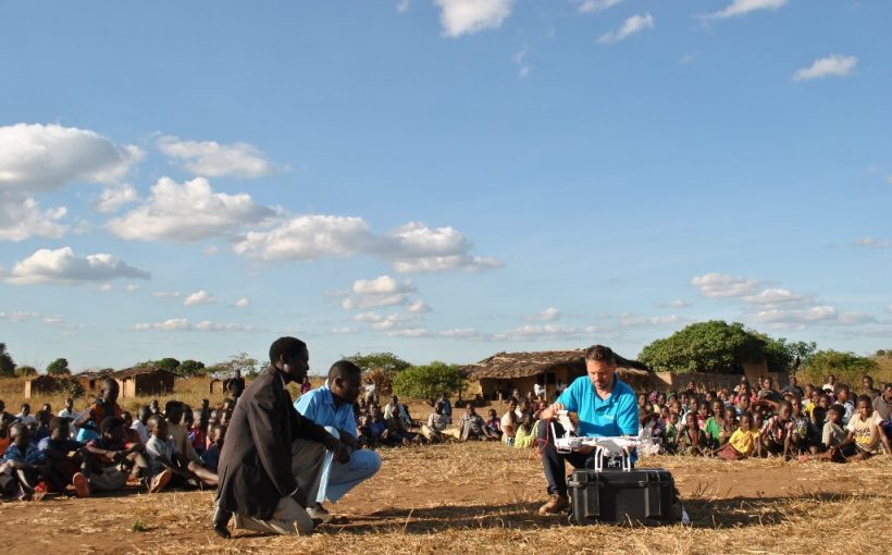
“Unifly provides the Unmanned Traffic Management system to ensure safe testing in the drone corridor. In this project, our software platform connects with uAvionix trackers to follow the drones in real-time,” said Marc Coen. The first test of the UTM System was in November 2017, during a fully autonomous, simulated blood sample delivery flight. The flight testing explored drone applications in emergency medical supply delivery, vaccines and sample delivery for diagnosis, and remote sensing. Drones can carry lifesaving materials, in places where developed transportation networks do not exist.
“A small community located 17 km from the aerodrome was chosen because of the health centre located there and the bad road connection to Kasungu. After one aborted test flight, the second try proved to be a perfect, fully autonomous flight to Kasungu airport. The flight took some 16 minutes and covered an actual distance of 19 km – find more information on the flights here.
“For us, the biggest challenge was the infrastructure, or lack thereof. Electricity and internet were intermittent, we also experienced some practical issues. The first time we set up a successful UTM system was back in November. However due to technical issues with the tracker, we were not able to follow the drone at that time.
“In November, the secondary goal of the test flight was for Virginia Tech to coach students and faculty from Malawian universities how to construct the aircraft so it can be fabricated and operated locally in Malawi for remote medicine delivery and remote sensing purposes. The drones are made of foam core (poster board) and 3D printed parts to facilitate local production and keep costs low.
“At the second UTM test earlier this month, Swedish FlyPulse and Globhe sent out a drone that combines transport with aerial photography. The goal was once again to deliver medical supplies to areas that are hard to reach, with another secondary goal to the mission. Their drone can capture and interpret aerial imaging. This way important information is made available, such as the quality of the roads, the number of houses in each area and the effects of possible natural disasters such as flooding. This drone flight was a lot longer as well, at 66km. For us, the second attempt was more successful because we could follow the drone’s movements on our screen in real-time.
“We believe it is very important to build an ecosystem of drone experts locally to ensure that these solutions are sustainable and embedded within the communities it services.”
The Malawi drone test corridor is open to industry, universities, and individuals who can apply and test a potential use case in one of the three main areas as defined below. The corridor will facilitate testing in three main areas:
Imagery – generating and analyzing aerial images for development and during humanitarian crises, including for situation monitoring in floods and earthquakes;
Connectivity – exploring the possibility for UAVs to extend Wi-Fi or cell phone signals across difficult terrain, particularly in emergencies;
Transport – delivery of small low weight supplies such as emergency medical supplies, vaccines and samples for laboratory diagnosis, including for HIV testing.
The corridor is designed to provide a controlled platform for the private sector, universities, and other partners to explore how drones can be used in scenarios that will benefit marginalized communities. All data generated by the flights will be used to inform the Government of Malawi’s plans for the use of drones in multiple scenarios. This is particularly important due to frequent flooding in some areas of Malawi and challenges in transport infrastructure.
(Image – Unifly)
