


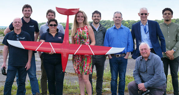
Peter Alty is the Project Coordinator for the SESAR Horizon 2020 Large Scale Demonstration Proving Operations of Drones with Initial UTM (PODIUM) project.
How long will the flight trials will go on for and when the report will be published?
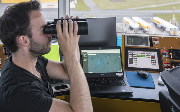
The main flight trials we’ve carried out across the five sites are taking place in the period March until the end mid-July this year. Several of the demonstrations are operational scenario flights taking place at the different sites where we run a kind of “war room” – all the participants meet together and very often we have an airfield where the drone’s actually being flown; we have controllers working in a tower and at some sites we even have general aviation aircraft participating.
By the end of July/August, each site will write an individual report and then we’ll produce a consolidated report which will be available on September 27. We’ll also have a dissemination event at Eurocontrol Brussels on October 17 for about 75 selected people. We want people who can really contribute, people we can usefully share our story with.
What is the main point of the report?
There are four key aims. The first aim of the project is to get people using the system, to really get some practical experience and to collect information. The demonstrations allow people to use a UTM system in a realistic operational environment, with drone operators, pilots, air traffic controllers and aviation over a period of time. This means they can get familiar with it, understand it and can think about what this really means to their practical way of working. A lot of the demonstration work is done by the participants themselves. We’ve performed 18 operational scenarios across all five sites.
The second aim is to assess the maturity – is this moving towards deployment, where we can really think about this being implemented? To do that maturity assessment Eurocontrol’s experts are providing input on safety, security and human performance. They’ve been asking questions of the participants; they’ve been involved in briefings and we’ve had some quantitative, objective information based on feedback from the community about ease of use and benefits.
The third aim is to make recommendations. We are at the start of a journey and need to make sure we head in the right direction. So we want to make recommendations about areas for improvement. We want the recommendations assist the European Aviation Safety Agency (EASA) regulation development, and we’re aware that they’re looking to September/October this year to have maybe a draft, and by the end of the year an opinion. We aim to share our findings, and want to make sure that our recommendations are taken into account by regulators in each of the states and also (to the extent that they are able to) by the EASA work.
The fourth aim is to really meet the expectations of the partners because this is a European-friendly project in part, but most of the partners are putting in their own contributions and we have to promote the partners in a positive way while maintaining the integrity that we need.
What are some of the more complicated operations that you’ve done?
First, I’ll explain the five sites that we have. We have the Drone Paris Region Cluster, at Brétigny sur Orge, with 300 hectares of airspace available up to 500ft and where they can almost do whatever they want in terms of scenarios and flight profiles.
Brétigny BVLOS trials
The second is at Rodez-Aveyron airport in the south of France which is in a Class Delta controlled CTR; there we have Delair flying fixed-wing drones in and out of the CTR in liaison with air traffic control. The third site is Odense at Hans Christian Anderson Airport in Denmark where we have an uncontrolled airport but with a tower and an AFIS edifice; then we have two sites at the Netherlands – the RPAS test centre at Marknesse and Groningen Airport Eelde which is a class Charlie airport.
We’ve gained valuable insights by performing BVLOS flights at all of the sites. A first for PODIUM was a BVLOS performed in a CTR in the Netherlands, in the airport environment, which took place on June 4 at Groningen Airport. But in order to get that done, NLR needed a lot of approvals and waivers and the whole exercise was very challenging; I consider it a significant achievement and gives an indication of the extent to which BVLOS is really used in certain countries.
At Odense we had a general aviation aircraft equipped with a GSM-based tracker/transponder which flew in the scenario so we were able to see the general aviation aircraft fly in the same airspace as drones. We were very careful about the segregation and were interested to see that we were actually able to monitor the GSM tracker to a height of 700 metres. It was 4G connection, a GSM-based tracker that had been provided by Southern Denmark University, weighing about 20g and it was used in the drones and the aircraft. So we got an air picture of everything that was taking place.
Another important achievement happened during a BVLOS flights at Groningen on June 4 when we performed in what is called an “unexpected scenario”. We had in the middle of the demonstrations a request for an air ambulance helicopter take-off, which it did. The airspace was effectively closed, although some airspace users in these cases are still able to use the airfield. Pleasingly, everything was perfect : coordination with the operators on the ground flying the drone, the air traffic control in the tower, our overall situational awareness. People were actually using what happens with the Unifly system, and the whole environment was shut in a safe way. NRL, the hub at Groningen, did a tremendous job.
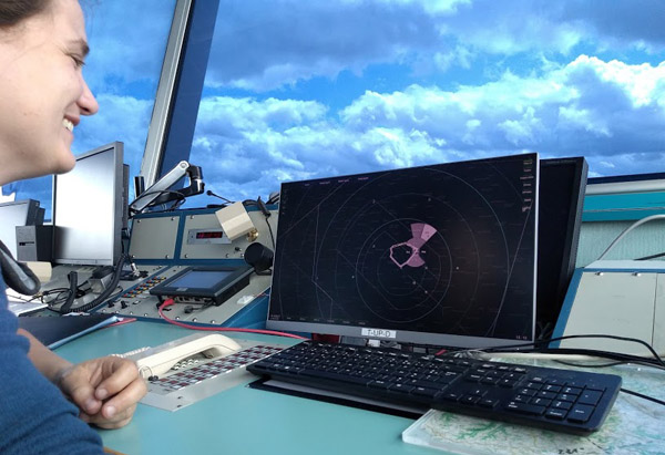
Situation awareness with Unifly at Groningen airport
In Rodez-Aveyron we’ve just had the dry run using Delair DT8 fixed-wing drones. They’re flying BVLOS in and out of the CTR and we have Airbus providing an integrated controller working position in the tower which shows the drone tracking and the manned aviation in the same stream. We’re doing some scenarios where we’re looking at for example the C2 link loss to see what happens.
Each of the five sites play their own part and the synergy, the sum, is greater than the individual parts. At the Drone Paris Region we have people who are in the drone business, their livelihood depends on it, and we’re getting some incredibly good insights from them about the daily challenges they face to get their flight authorisations, to feel safe flying in the airspace. EUROCONTROL’s mission is to support aviation and we are happy to have this very innovative group of small and medium enterprises in the drone business giving feedback in a constructive but very direct way.
What about integrating counter UAS systems to test what you can detect and ADS-B links?
Operators have told us that when they see other drones in the airspace and can find out quickly that those drones are supposed to be there (through identification and tracking) that is already reducing some of the clutter. We also have a very significant partner at the Drone Paris Region, Cerbair, who have a cost-effective solution for detecting and neutralising drones. They are due to use the UTM system, giving us feedback and giving us some ideas, but we’re not doing a live trial as such; it’s not a main focus of the activity, but we are taking it into account. It’s more a case of expert involvement.
We’re using the three kinds of tracking technology, allowing us to compare. One is GSM-based tracking technology which is being used at Paris and Odense. The second is ADS-B – using the uAvionixs tracker in Netherlands. And we’re using a technology which is being led by Airbus which is called ultra-narrow-band, L-band technology which is satellite-based. Our initial findings are that the technology is able to track the drone and to provide a situational awareness. But there are some robustness issues, and this is a key finding. For example, when a fixed-wing drone is in a turn on some occasions we’ve lost the track and we realise now that the integration of the tracking device on the drone and in terms of the coverage of the network is really important. So it may be that the ability to track a device using GSM-based tracker is actually significantly impacted by the location of the antennas of the 4G network.
There is a regulatory timeline. Are you under pressure?
Eurocontrol’s raison d’etre is safety and while I’m very positive about the opportunities of UTM, when we produce the final report we have to maintain our integrity and highlight any issues that we consider require improvement; we have to keep safety in mind. We have to do the work in the right way and in a steady way and make sure that all of the bits of the system work together. Because if we’re looking at a long-term future we should make a really solid foundation. We’re going to be very transparent about any areas where any improvements are needed.
How is UTM/U-space going to be integrated with ATM?
At the sites where we’re looking at the integration with controller, there is Odense to a certain extent with the AFIS (aerodrome flight information service), although that’s flight information, but the main areas are at Groningen Airport where we have the tower and controllers; the other is Rodez-Aveyron airport and we’ve had positive feedback about what we’ve done at both sites. I’ve seen the way the controllers are working and it’s going fine. We’ve noticed that it is essential to minimise the workload implications for the controller. Initial feedback is controllers want as little interference as possible, so for them, clear, consistent phraseology and automation which supports their ability to see where the drone is, is necessary and dealing with any requests is key because their main concern is manned aviation and they want as little workload implications from drones as possible.
Will that feed into systems display which controllers will have?
At Groningen we’re using a separate display from Unifly where the controller can see the display. At Rodez-Aveyron airport there is an integrated controller position which has been provided by Airbus and that shows all of the manned aviation and the drone traffic on one screen.
Have you flown the drones in severe weather?
We don’t have all-weather operations at the moment, but the team working at Odense, led by Integrate Aerial Systems, have a lot of experience of extreme weather conditions – in January temperatures were down to minus 4/5. All the preparation must be correct – for example putting the tracker on the drone. Quite often operators take two drones to a job so if a drone is not working properly due to the cold and they need to transfer the tracker from one drone to another then physical robustness and the way that the tracker’s integrated on the drone are important.
Also, in certain cases we’ve decided not to proceed with demonstrations because the wind gusts have been unsuitable and we’ve been unable to perform.
Airbus Integrated Controller working position at Rodez
What are some of the other key findings of the work so far?
Helping the whole flight authorisation area is key.
Some operators are telling us that it’s taking at least 70% of their effort in each job to get the authorisation for a flight; sometimes it can take weeks and involve a number of organisations, and this has an impact on business. Any system which helps them to gain authorisations more quickly and efficiently will be very beneficial.
The second area is situational awareness and having confidence that all the other actors know that their drones – and other drones in the area – are flying where they are supposed to be flying and can be identified.
We’ve noticed some areas which are vital in terms of a European perspective. Robustness of trackers – making sure that the integration on the drone and the performance of the tracker is correct – is an area that needs to be worked on.
We also see that although Unifly are doing a great job as it’s challenging to produce a human-machine interface which is the same for the three countries that we’re working with. We need to have a system which is capable of coping with the different legislation in each of those three states and can give us the approval authorisation of the flight. The airspace data and the way that the legislation is presented in the systems is not harmonised across the states. This will hopefully be improved by the new drone regulation which has been issued by the European Commission, but the practical issues arising from differences in legislation have made it challenging.
Also, we’ve observed that operators are using various sources of information to find out where they can and can’t fly. When they are preparing a flight and looking at the airspace and legislation data they need to be able to trust the system, trust the data, and if they are unable to trust the data, then they may be obliged anyway to look at another source of information. So having a single interface where they get their authorisation to perform a flight is essential.
We have aeronautical information where you provide information that’s been aimed at the air traffic management community. But with the drone operators flying at below 500ft the information is not necessarily there and we see this as an area for attention.
Generally we’re very positive about the opportunities with UTM/U-space particularly with the ability to have more efficient flight authorisations and with the ability to provide a situational awareness. However, our aim is to be transparent about any areas where there is a need for improvement, in particular where there is a safety implication. That will be the thrust of the report that we produce in September and that we publish in October.