


In-Flight Data and AirMatrix report successful completion of a SAIL 4 urban drone operation beyond visual line of sight (BVLOS) over urban neighbourhood populations in Canada.
SAIL refers to the combined complexity of a drone mission, from 1 (low) to 6 (high). Only two other projects of this level and scale are known to have been completed in the world to-date, both in Europe, says the press release.
The project successfully completed 3D mapping of the urban network fabric to understand and assess how future UAM drones and infrastructure can take advantage of these new high-performance networks to deliver future innovation to the cities and their citizens.
According to the press release:
Since March 2022, In-Flight Data has been testing, training and preparing to conduct advanced aerial surveys within the city of Calgary through the city’s Living Labs Program. This program aims to offer up access to city assets for companies, researchers and individuals to test and try ideas and products in a real-life environment, helping entrepreneurs bring big ideas to fruition and supporting investment in the local economy.
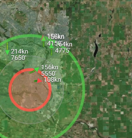
In July and August 2022, the flight missions covered an operational area of about 9,000 hectares (about 22,000 acres) entirely inside the city of Calgary, with a population of about 1.34 million people.
Utilizing a trained air crew working with advanced operations certified drones and the latest in advanced radar and aerial surveillance technologies, including hardware and software, the flight crew was able to see all Calgary air traffic users for more than 30 km in all directions. The purpose of the aerial intelligence gathering was to measure and assess the quality and performance of the entire communications network fabric above an urban center including geolocation, cellular, radio and many others.
This understanding of the network performance is required to support future advancements in aviation. These advancements include amazing technical achievements like medical deliveries – such as human organs, medications or devices. This mapping also supports the development and growth of urban air mobility (UAM), like flying taxi’s such as Uber or Joby.
Telecommunications companies, governments, regulators, airspace navigation service providers, and industry alike will all need to understand how high-performance drone aircraft will safely navigate and communicate in the air above population centers. Think of it like when the Canadian Pacific Railway was built in the 1800’s – someone came before the rail lines to survey the route, level the land for the rail ties and dig tunnels through mountains.
For more information visit: