


Computer vision company ProTrack is launching two software products at the DroneX Trade Show & Conference in London 5-6 October. Both software solutions enable air traffic safety and supply chain continuity in an increasingly complex flight environment.
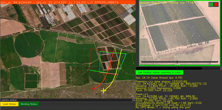
Yoav Rosenberg, ProTrack’s CTO explains: “ProTrack has developed Locator – a real-time software engine that uses very robust and precise video-anchoring capabilities to assist positioning. To put it simply – it calculates the position of the platform by matching its real-time video to a map. The software is installed onboard using a standard processing card, such as NVidia Nano, Qualcomm or similar, which receives video and telemetry and outputs the correct positioning data. It can use the existing onboard PTZ or fixed camera (daytime/thermal/IR) or a dedicated simple camera.” The integration process is short and straightforward and there is no need to purchase any new navigation or communications equipment. The application is installed on the aircraft or on the ground-control system and is currently used by drone manufacturers. It is also suitable for aircraft manufacturers and navigation equipment manufacturers.
The company is also presenting its Flight software, a video anchoring and geo-positioning tool for airborne platforms. The software extracts real-world coordinates of any pixel in day/night real-time video. It also incorporates ProTrack’s proprietary, military-grade VMD (Video Motion Detection) and Object Tracking capabilities. Flight can be seamlessly integrated into existing C4I systems, or operated as a standalone. Customers that will benefit from Flight include security agencies, the military, civilian surveyors, and engineers.
The products are designed to support navigation in GNSS-denied environments by adding a secured element that corrects GNSS and INS data in real time; and maintain a correct position even when they are not working at all, without relying on any outside communications.
GNSS positioning is vulnerable to interference, and spoofing (i.e., transmitting bogus GNSS signals to confuse navigation systems) is another acute concern. Inertial Navigation Systems (INS) tend to “drift” over time and their output becomes less precise with the passage of distance and time. ProTrack says its solution is designed to keep airspace users flying securely and prevent accidents occurring.
(Image: ProTrack Locator)
For more information visit: