


By Thiago Tavares, VVA Brussels
According to the United Nations[1], more than 55% of the world’s population lived in urban settlements in 2018 and 60% of people are expected to live in cities by 2030. As a result, the density of people in urban areas has increased and challenges related to mobility and traffic became part of the routine of most inhabitants of cities globally. Other trends impacting mobility include the rise of e-commerce brought mostly by giants such as Amazon and Alibaba and the decarbonisation of cities. Therefore, it seems natural to explore new, more ‘ecological’ and more efficient means of delivery such as drones.
However, there are still important question marks remaining about drones: are drones the best option in comparison to other ‘ecological’ vehicles such as electric bikes and electric vans? Will drones replace traditional delivery methods or create new niche business opportunities? Among others, cost is a key element to be assessed in order to answer this question. VVA, a consultancy company based in Brussels, developed a cost assessment model to analyse different business cases for using drones in the delivery of biomedical samples, food and parcels and compared different satellite navigation solutions. This was done in the context of the project EGNSS4RPAS[2] financed by the European Commission.
When time is critical, delivering biomedical samples with drones is best
In the healthcare sector, time is vital and can save times. That is why the transport of biomedical and specimens’ samples between hospitals or laboratories needs to be done as fast and timely as possible. Currently, most hospitals and laboratories use traditional courier services which means that despite the small size and weight of each sample, they typically need to wait for a minimum volume before dispatching them. Moreover, what can further delay the process is that delivery time is not always constant as it depends on traffic conditions. In this context, drones come as a good solution because of their ability to provide faster, cheaper and more reliable delivery services.
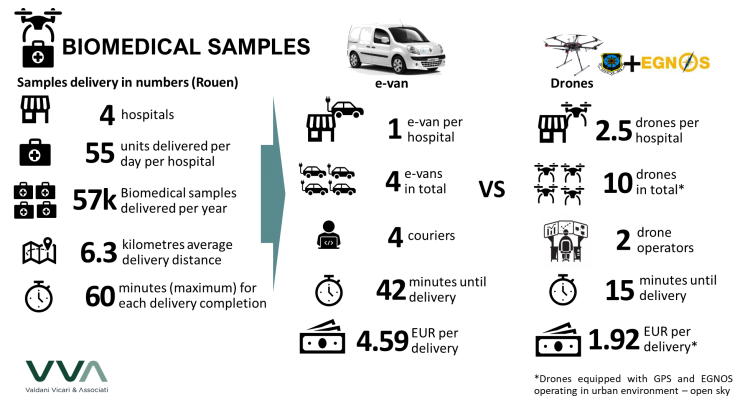
The cost assessment analysis undertaken by VVA compared the cost-effectiveness of drones[3] in relation to electric vans for the delivery of biomedical samples. The case study analysed the transport of samples in the city of Rouen (France) between three hospitals located in three different areas of the city sending samples to the central hospital that has the necessary equipment to carry out the analysis of the samples and provide diagnostics. Based on discussions with stakeholders, it is estimated that 11 deliveries per day are undertaken between these hospitals and the average distance between sites is approximately 6.3 km. Although each sample package weights less than 2 kg, as the delivery are currently done by 5 utility vehicles, each delivery package currently combines samples up to a maximum weight of 30 kg per delivery to reduce the number of required delivery trips.
For the future scenario, the analysis considered the replacement of the current vehicles by either electric vans or drones. For the drone scenario, fixed routes between the different hospitals, possibly from rooftop to rooftop, are considered. This would mean that most of the operation would be performed under open sky, what would also make the flight approval process less complex.
The outcomes of the analysis indicate that the delivery of biomedical samples with drones would take approximately 15 min, almost a third of 42 min estimated for e-vans. In addition, the delivery by drones is also expected to be 60% cheaper. The cost per delivery by drones is estimated at EUR 1.92 while delivery with e-van would cost EUR 4.59. The analysis also concluded that EGNOS solution is the preferred option to support drone navigation not only because of the higher position accuracy in comparison to GPS but mainly because it provides timely warnings to users when the system should not be used for navigation (so-called system integrity), feature that is critical for operations in urban areas where the risk over people on ground is higher.
The conclusion is that in time-critical operations (less than 60 min), the higher speed and reliability of delivery of biomedical samples are essential. Therefore, the higher cost-effectiveness makes the delivery by drones advantageous. It would also make the delivery more reliable and independent of the traffic conditions in the city. On the other hand, when time is not as critical (for example, if the delivery could take more than 2 hours), the larger volume of the e-van would make it more cost-effective than drones.
Food delivery with drones: urban v suburban areas
From pizza to sushi, ordering food from home has become a habit to citizens in most urban areas. Although the coverage of delivery services is quite satisfactory in cities, delivery options in suburban areas can be scarcer due to the lower density and higher distance from the restaurants to their customers. Several companies have been undertaking flight trials to demonstrate the technical feasibility of delivering food with drones, including Google’s Wing and Domino’s pizza. Among the different vehicles currently in use, bikes and electric bikes are among the preferred options for food delivery services.
To assess the business case for food delivery with drones, the Domino’s pizza delivery services in London was selected, hypothetically. Based on the data published by Domino’s about their delivery services in the UK[4], it is estimated that each of the 16 Domino’s restaurants in London deliver on average 300 pizzas daily and that the maximum delivery time is 25 min. Imagine you are ordering a pizza from the famous Piccadilly circus from the closest Domino’s restaurant, located at Holborn. With an e-bike, the delivery would take 13 min and cost EUR 1.90. With drones, you’d be able to get your pizza delivered in 6 min and it would cost only 89 euro cents. Isn’t that better when you are very hungry, or you have a full party to feed? Probably yes.
However, some business aspects have to be highlighted. Firstly, as each drone is estimated to cost more than EUR 4,000, the initial investment and maintenance costs are twice as high for drones than for e-bikes while the main cost savings are thus related to reduced labour costs. Secondly, for food to be delivered by drones from restaurants to homes (door-to-door), this would imply the operation in a challenging setting due to the variability of delivery routes and safety risks linked to the high density of people, probably requiring a longer flight approval processes. Finally, urban areas imply that obstacles, such as high-rising buildings could reduce the visibility of satellites for navigation purposes. Therefore, the business case for delivering pizzas in urban areas with drones is not yet evident.
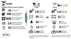
On suburban areas, the situation is different. If the average delivery distance would increase to 5 km, e-bikes would fail to provide a sustainable business model while ensuring the high quality expected to customers, which in this case means: delivering hot food for a reasonable price. On the other hand, drones appear as a great complementary service to cover these areas and could perform the same delivery in 11 minutes and it would cost EUR 1.55, which is in some cases cheaper than the current delivery costs in urban areas. Therefore, drone delivery could play an important role in enhancing the current offers of food delivery in suburban areas and enlarging the coverage of the delivery businesses.
In both cases, the system-integrity provided by the EGNOS solution is considered as a critical feature to ensure safer drones operations in rural and urban areas.
What about last-mile parcel delivery with drones?
The rise of e-commerce, thanks mainly to the giants Amazon and Alibaba, has changed retail as we know it. According to Pitney Bowes[5], there were 87 billion parcels delivered worldwide in 2018 and the volume should reach 200 billion by 2025. Considering the Amazon estimates that around 86% of the items delivered by them are lighter than 2.27 kg and therefore could be delivered by drones, should we expect drones dominating this huge market?
To answer this question, a business case for the bpost New Brussels X parcels sorting facility is analysed. The New Brussels X has 80,000m² and it is the biggest in the Benelux and the second biggest in Europe. It is responsible to handle parcels for the whole Belgium and we estimate that approximately 60,000 parcels are destined to the capital, Brussels.
The cost assessment analysis shows that for same-day deliveries, e-vans are the most cost-effective vehicles with the cost per delivery at approximately EUR 0.14 while for drones the cost was estimated at EUR 0.59. It is clear by this assessment that the higher capacity of the vehicle plays an important role to its efficiency.
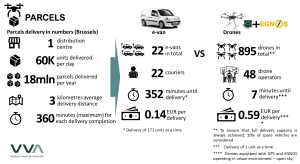
Nevertheless, in the scenario of express delivery within 30-minutes from the order, drones become more competitive. The analysis indicates that in such scenario, the cost per delivery per drone is expected to be EUR 1.00 while the cost for the e-van rises to EUR 4.35. In this scenario, it estimated that the optimised routing thanks to the additional accuracy and safety features provided by EGNOS would represent an average gain of 3 cents per delivery in comparison to GPS-only solutions.
The results of the analysis indicate that drones might not replace the full last-mile delivery of parcels but rather cover a niche market for express delivery of products, which is in line with the current business model being considered by Amazon Prime Air.
Why equipping drones with European satellite navigation makes sense
Drones currently rely on multiple sensors for their navigation, positioning and obstacle avoidance. Lidar and infrared sensors are commonly used to support navigation and obstacle avoidance functions. For absolute positioning, GPS is still the main solution used but European Satellite Navigation solutions –EGNOS and Galileo- are becoming mass-market and gaining terrain in the drones’ segment. Moreover, in the near future, Galileo will deliver unmatched services like OSNMA (Open Service Navigation Message Authentication), which will enhance protection against certain cyberattacks, and High Accuracy Service, with position accuracies down to 20 cm.
Within the EGNSS4RPAS project, field trials were undertaken in segregated airspace and urban areas by the consortium partners, GMV and CATEC, to compare the performance of GPS-only solutions with solutions including Galileo and EGNOS.
The trial results indicate that the use of Galileo in dual constellation (GPS+Gal) significantly improves GPS-only performance in terms of accuracy, availability and continuity. EGNOS, being an augmentation system, not only enhances the position accuracy of GPS down to sub-meter level, but also can provide timely warnings to users when the system should not be used for navigation (so-called system integrity).
| Position error | Mean [m] | Percentile 95% [m] | ||
| Horizontal | Vertical | Horizontal | Vertical | |
| GPS-alone | 0.554 | 2.272 | 0.897 | 3.379 |
| Galileo-alone | 0.262 | 0.439 | 0.653 | 0.860 |
| GPS-Galileo | 0.442 | 1.351 | 0.880 | 2.034 |
| GPS-EGNOS | 0.285 | 0.239 | 0.362 | 0.495 |
Table 1: Position error results from trials for open sky operations – Multicopter and GNSS single-frequency
Table 1 presents the results of the trials undertaken to simulate open sky operations with drones. The horizontal position accuracy achieved by the EGNOS solution was 60% more accurate than GPS-only, reaching less than 40 cm. For the vertical accuracy, EGNOS achieved accuracy below 50 cm, which is a great improvement if compared to the 3.4 m accuracy achieved by GPS-only.
The horizontal and vertical position error deriving from the trial results were converted into a distance adjustment factor that was used to simulate the trajectory undertaken by the drone in comparison to the most direct trajectory (position error = zero). Under normal conditions with open sky without disruptions, it is estimated that EGNOS would be able to ensure that the most direct trajectory is followed while the GPS-alone solutions would have an error of 1%. However, when the visibility of satellites could be blocked by certain obstacles, such as urban areas with high rising buildings, the error of GPS-only solutions could almost reach 40% while EGNOS could remain with an error at only 1%. In addition, as EGNOS’ integrity messages enhance the overall safety of the operations, it is expected that insurance primes charged to drone operations could be lower due to the lower risks involved. The cost assessment considered a 5% reduction, conservatively.
It is important to highlight that as EGNOS and Galileo are already mass-market in several sectors, they are provided by the main receiver manufacturers, such uBlox, at no additional cost.
The outcomes of the cost assessment indicate that the combination of higher accuracy and integrity message could represent gains between EUR 0.01 and EUR 0.03 per delivery. If we hypothetically consider the business case for the delivery of parcels by post, where almost 19 million parcels are delivery annually, the total net benefit per year could surpass EUR 500,000. The technical analysis and the cost assessment carried out under the project confirms the clear business case for the use of EGNOS and Galileo combined with GPS for position and navigation purposes.
About the EGNSS4RPAS project
VVA, together with GMV and CATEC, has been contracted by the European Commission’s DG GROW to provide support to the standardisation actions for EGNSS (EGNOS & Galileo) in Drones/RPAS/UAVs. This project has been implemented for one year until September 2019. It falls under the overall context of the Space Strategy for Europe, adopted by the Commission in October 2016, and focuses on the aviation segment, more specifically on drones, which is an upcoming and fast evolving subsegment of aviation. The project is a contributor to the U-Space Network of Demonstrators set up by the European Commission.
For more information, please contact Thiago Tavares: t.tavares@vva.it
[1] United Nations, Department of Economic and Social Affairs, Population Division (2018). The World’s Cities in 2018—Data Booklet (ST/ESA/ SER.A/417)
[2] See project description at the end of the article
[3] The comparison considered drones using GPS and EGNOS within their navigation systems.