

NTT DATA Corporation has launched a drone traffic management software package “airpalette® UTM” (www.airpalette.net/utm) to drone operators and local governments.
The software package enables simultaneous remote control of multiple drones of different models, thus improving the efficiency of infrastructure inspections and disaster responses that would be dangerous and time consuming for human workers to conduct.
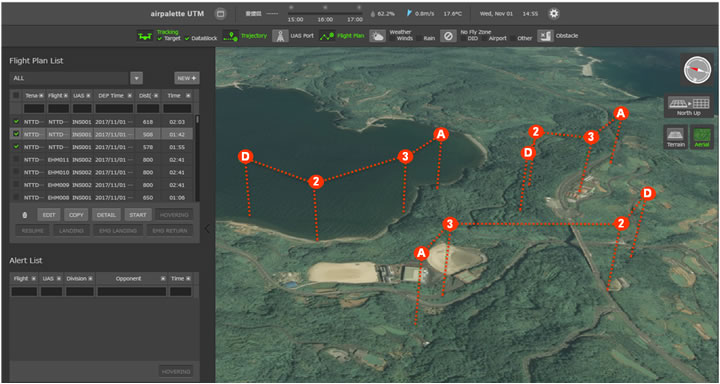
The airpalette UTM software package consists of two functions: an “FOS” (Flight Operation System) drone operation control function that enables simultaneous remote operations of multiple drones and a “UTM core” (UAS Traffic Management core) unmanned aircraft traffic management function that centralizes the management of position information of multiple drones operating in a certain airspace.
The FOS function enables:
- Remote operation of drones using various types of networks
- Simultaneous control of multiple drones
- Flight planning function (flight date and time; latitude, longitude, and altitude information of takeoff, passing, and destination points; air speed; etc.)
- Drone self-position display function
- Drone and user information management function
- Map, no-fly zones, weather, and topographic information display and management function
- Interfacing with business software or other external information (map information, weather information, information of other nearby drones, etc.)
- Flight plan application function*
- Manned and other aircraft position information, NOTAM*2, and radio wave coverage area*3 information display function*
The UTM core function enables:
- Overall monitoring such as monitoring of multiple drone positions
- User information management
- Flight plan confirmation function (flight date and time; latitude, longitude, and altitude information of takeoff, passing, and destination points; air speed; etc.)
- Transmitting various information (flight plans of other aircraft, information of other aircraft, airspace information, NOTAM, etc.) to FOS*
- Flight plan verification that takes into consideration map, no-fly zones, and topographic information
- Manned aircraft information provision
- Mid-air collision possibility detection
- Inter-operator adjustment (airspace management, air traffic status management, etc.)*
During the nuclear emergency exercise held in Ehime Prefecture on November 14, the airpalette UTM function successfully controlled a drone from the Ehime Prefectural Government Office located about 70 km away from the nuclear power plant and provided the camera images of the evacuation routes near the power plant to the concerned parties in real time.
