


Israel has successfully tested Beyond Visual Line Of Sight (BVLOS) civil drone flights in GPS denied environments using a special drone test zone in Yeruham. The test is part of NAAMA, the Israeli drone delivery pilot program operated by Israel’s Ministry of Transport (MOT), Ayalon Highways, the Civil Aviation Authority of Israel (CAAI) and Israel Innovation Authority, for testing and demonstrating drone technologies in managed airspace (UTM).
The current test is examining how vision-based navigation technologies can help drone operators address the increasing threat of GPS signal disruption. This kind of disruption can originate from a bevy of sources, including enemies seeking to disrupt a military mission, individuals using them for their own purposes, satellite malfunction, and even solar flares, making it critical to develop other forms of navigation and reduce our reliance on GPS. Keeping a safe flight route in a GPS-denied environment is an essential condition for autonomous drone flights, to ensure that the operated drones do not endanger people, cars or other aerial vehicles. The test included a GPS jammer to create GPS-denied zones and demonstrated how the drones navigate safely to their destinations without relying on the satellite infrastructure.
The successful test is an important milestone towards the approval of drone delivery operations in Israel. The global market for autonomous drone flights is predicted to reach a few billion dollars in the near future.
The test was conducted as part of a bid process held by Ayalon Highways which has been scouting for technologies that resolve the threat of GPS disruption in drone operations. Sightec, which developed Visual Situation Awareness system for autonomous flights based on computer vision and artificial intelligence technologies, was selected to present its solution for vision-based navigation in collaboration and integration with Simplex Interactive (Simplex-c2.com) that developed FlightOps.io drone operating system which allows operation of multiple drones beyond visual line of sight and in shared airspace.
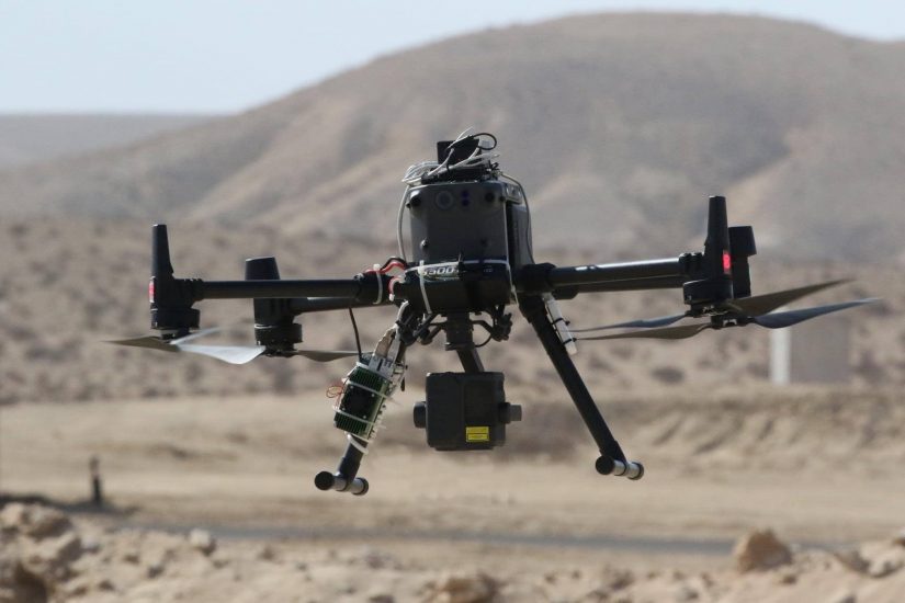
The NavSight system developed by Sightec enables camera-based visual situation awareness for autonomous aerial day and night missions, including vision-based navigation and landing (GPS-free), detection and classification of ground and aerial objects as well as 3D mapping & change detection for a full understanding of the ever-changing environment of the drone. NavSight turns off-the-shelf cameras into smart affordable sensors that enable the drone to “see and understand its surroundings” like the human pilot.
NavSight integrates algorithmics from leading academic research, including developments at Ben Gurion University’s lab lead by Prof, Joseph Francos, the company’s Chief Scientist together with deep learning technology. The company’s clients include drone and avionics integrators for reconnaissance and Homeland Security missions such as Israeli Aerospace Industries (IAI) and Elta Systems, along with drone integrators in a wide range of civil applications including delivery, mapping, security and first responders.
FlightOps multi-drone operating system that was developed and implemented by simplex-c2.com allows the operation of autonomous commercial drone arrays beyond visual line of sight and in shared airspace with other drones and aircrafts. The company has won several major contracts with the Israeli ministry of transport and the Ayalon Highways NAAMA initiative to implement its technology for drone deliveries and urban air mobility.
FlightOps drone operating system is the only technology certified by the civil aviation authority in Israel to fly commercial urban drone deliveries Beyond Visual Line of Sight (BVLOS) and has already performed hundreds of commercial flights as part of the NAAMA initiative.
The integration of Sightec visual navigation capabilities together with the advanced autonomous capabilities of the FlightOps.io drone operating system allows enhanced safety while operating multiple drones Beyond Visual Line Of Sight (BVLOS), also when both the GPS and the drone’s communication are lost.
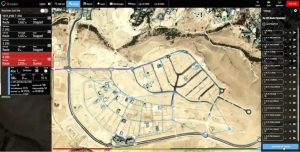
A screen shot from one of the navigation tests conducted in the test field in Yeruham. The purple line shows the vision-based navigation on top of a pre-defined route.
(Image: Yeruham, Dror Ben David, Matrix)
For more information visit: