




By Philip Butterworth-Hayes
The Ohio Department of Transportation (ODOT), through DriveOhio, has released its three-year plan to enable and scale advanced air mobility (AAM) operations in Ohio, including a radical new digital information network to support drone and eVTOL flights combining air traffic management, vertiport and aircraft operational communications.
The plan is to create a statewide digital enterprise (DE) network that will allow aircraft operators, service providers, and public agencies to securely share information. This system will support advanced operations such as beyond visual line of sight (BVLOS) flights and more efficient transportation and delivery services.
The DE integrates operational, infrastructure, and environmental data to support AAM operations across Ohio, says the DriveOhio plan. By providing improved situational awareness, information sharing, and coordination capabilities, it helps stakeholders identify operational needs, evaluate infrastructure gaps, and inform future investment and policy decisions. Because technologies and regulations continue to evolve, the framework is intended to remain flexible while supporting informed decision-making consistent with federal authorities and oversight responsibilities.
“The DE constitutes a federated data exchange and C2 framework that supports cooperative operating environments where BVLOS operations can be performed safely. The concept is consistent with the FAA’s proposed Part 146 ADSP requirements and aligns with USDOT and FAA data exchange services. Ohio’s DE serves as a planning and operational framework for evaluating how communications, surveillance, information exchange, and coordination capabilities may support future AAM operations. It is not a single system, platform, or technology solution but rather an enabling architecture that helps Ohio and its partners evaluate operational data, coordination requirements, governance approaches, and infrastructure needs as AAM operations become more frequent and complex. Each participating DE node acts as a separate AAM data exchange service that aggregates and redistributes verified air and ground data. This includes aircraft position and intent, weather, surveillance, infrastructure, and emergency status. The DE supports safety by implementing data quality controls, monitoring system performance, and maintaining acceptable latency thresholds. The DE complements but does not replace existing Air Navigation Service Provider (ANSP)/NAS services. Initially, it will operate in an information access and sharing capacity. Over time, it will transition to a statewide federated data exchange with diverse stakeholders providing and receiving data in accordance with emerging federal regulations.
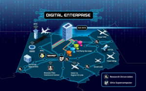
“The DE will enable situational awareness across State, Federal, and operator communities, ensuring interoperability consistent with Remote Identification (Part 89) and other data-sharing requirements. As federal rulemaking evolves, including anticipated Parts 108 and 146, Ohio will continue refining the DE framework to align with emerging operational, safety, and data-sharing requirements.
“As AAM operations scale in frequency and complexity, Ohio will use extensible traffic management (xTM) capabilities as part of its broader DE approach. These capabilities are intended to complement—not replace—existing FAA air traffic control systems, particularly in low-altitude environments and higher-tempo operations where traditional surveillance and coordination may be limited. Ohio’s approach is to use xTM functions incrementally and use data generated from real operations. Early evaluations focus on digital services operating in a “shadow mode,” where they provide advisory information alongside existing human procedures rather than exercising operational control.”
Work on this three-year plan (2026-2029) has already started. Key infrastructure, including advanced airspace technologies and electric aircraft charging stations is already in place or being evaluated to support the operation of eVTOL and conventional takeoff and landing (CTOL) aircraft throughout Ohio. Operational testing in Ohio is supported by the SkyVision ground-based detect-and-avoid system, a collaborative development of the Air Force Research Laboratory (AFRL) and ODOT’s Uncrewed Aircraft System (UAS) Center. Early AAM and UAS operations at KSGH leveraged initial SkyVision deployments (SkyVision 1.0) to enable safe, BVLOS operations. Future testing and pilot project activities will incorporate SkyVision 2.0, which will provide enhanced surveillance and operational monitoring capabilities to support more complex use cases.
There are three phases to the plan:
- Phase 1: Planning (2026-2027) Focuses on establishing statewide alignment, air and ground infrastructure analysis, and foundational planning for multiplatform advanced aircraft operations and data management. Activities center on defining priorities, coordinating with local and regional partners, advancing airspace and infrastructure planning and assessment and preparing data systems, and reporting frameworks
- Phase 2: Implementation (2027–2028) Market driven pilot and demonstration activities to generate real-world operational insight to establish initial operational AAM route(s). These efforts will test AAM use cases across varied environments and will be designed to inform safety, regulations, infrastructure needs, data exchange requirements and mechanisms, and policy considerations.
- Phase 3: Preparing to Scale Operations (2028–2029) Synthesize lessons learned from earlier phases to refine policies, identify infrastructure investments, define the roles for the state, communities, and industry in the AAM ecosystem, strengthen regional coordination, and prepare the state for broader AAM adoption as regulatory and market conditions mature.
For more information
https://drive.ohio.gov/programs/advanced-aviation/advanced-air-mobility/aam-plan
(Image: DriveOhio)