


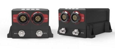
Honeywell has introduced a new inertial navigation system called HGuide n380 that communicates position, orientation and velocity of an object — such as an unmanned aerial vehicle (UAV) — even when global navigation satellite signals are unavailable. The HGuide n380 is lower-priced and has a smaller footprint than previous Honeywell inertial navigation systems and is designed to withstand harsh environments in the air, on land or at sea, according to the company.
This new inertial navigation system is composed of Honeywell’s HGuide i300 inertial measurement unit (IMU), a global navigation satellite system (GNSS) receiver and Honeywell’s proprietary sensor fusion software, which is based on the algorithms used for navigation on millions of aircraft every day. Inputs from these components are fused together to determine position, orientation and velocity to deliver critical navigation information even in areas where a satellite signal is degraded or altogether unavailable, such as canyons, bridges, tunnels, mountains, parking garages or dense forests.
The HGuide n380 output data includes time stamped position, velocity, angular rate, linear acceleration, roll, pitch and heading information. In dual-antenna mode, the device supports GNSS-based heading measurements and initialisation.
“We recognized a need for a small, high-performance inertial navigation system in areas like 3D mapping, surveying and other applications where space is at a premium and performance cannot be compromised,” said Chris Lund, offering management senior director, Navigation and Sensors, Honeywell Aerospace. “We responded by developing the HGuide n380 inertial navigation system, which provides our customers with proven, cost effective inertial sensor technology, created for aerospace applications, but that can be integrated into almost any architecture.”
Lund added: “As the industry evolves, Honeywell’s HGuide suite of IMUs and navigators will be a key enabler of emerging segments like autonomous vehicles, mobile mapping, precision agriculture, robotics and surveying.”
For more information visit: