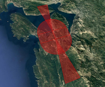
Guidance from ICAO and the European Aviation Safety Agency (EASA) recommends Electronic Terrain and Obstacles Database (eTOD) is provided by state Aeronautical Information Publications (AIPs) to support a wide range of applications such as:
- Determination of contingency procedures for use in the event of an emergency during a missed approach or take-off;
- Aircraft operating limitations analysis;
- Instrument flight procedure design;
- Determination of en-route “drift down” procedures and en-route emergency landing location;
- Transition from AIS to AIM (Aeronautical chart production and on-board databases)
- Flight simulators;
- Unmanned Aerodromes Synthetic Vision;
- Aerodrome / Heliport Obstacle restriction and removal.
NAVBLUE meets ICAO Annex 15 definition describing the areas and requirements for eTOD accuracy and resolution. The company delivers eTOD to operators and other stakeholders in order to enhance safety and increase efficiency of flights.
NAVBLUE data covers all ICAO areas 1-4: Area 1 is the entire country, Area 2abcd is the vicinity around the airport, Area 3 is the area around the runways and taxiways and Area 4 the small area at the end of the runway when using ILS CAT II or III W.
NAVBLUE has in-house access to Pléiades high-resolution optical Earth observation satellite and other optical or radar satellite sensors operated by Airbus Defence & Space. Airbus new Pléiades Neo constellation of four optical satellites, two of which are already operational and two to be launched mid-2022, provide high-quality images at 30cm resolution and will improve obstacle detection.
Airbus Defence & Space photogrammetrists use proprietary tools to extract eTOD data from the stereo satellite imagery, complemented by on-site data survey and drone capture when necessary, to achieve the completeness, accuracy and resolution required for each of the areas.
The typical eTOD deliverable for obstacles is a database in Aeronautical Information Exchange Model (AIXM) or .shp format, or similar; and terrain in elevation grid format. This can then be made available to the aviation community through the state Aeronautical Information Publications (AIPs).
NAVBLUE already uses eTOD for several projects for airports such as Tivat Airport, Montenegro and major Terminal Manoeuvring Area (TMA) redesigns in Latin America. NAVBLUE can also meet additional customer needs such as eTOD monitoring, Obstacle Limitation Surface (OLS), orthoimagery and Airport Mapping database (AMDB).
For more information visit:


