

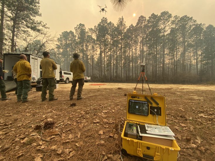
NASA researchers recently tested a mobile air traffic management kit for remote ground pilots across forests throughout Tennessee, Mississippi, Georgia, Florida, and South Carolina. During the testing, U.S. Forest Service pilots remotely operated Unmanned Aircraft Systems (UAS), or drones, to drop ping pong ball-sized plastic spheres that ignited on impact, precisely burning dead brush that acts as fuel to wildfires. The testing was in support of NASA’s Wildland Fire Management Initiative.
The Aerial Ignition Academy training, hosted by the US Forest Service, in collaboration with the National Interagency Prescribed Fire Training Center, provided pilots with a chance to train using drones for prescribed burns, a wildfire prevention and land management technique that employs the controlled use of fire to burn fuels like dead brush and vegetation. During the training, researchers from NASA’s Advanced Capabilities for Emergency Response Operations (ACERO) project shadowed drone pilots as they trained in the field and collected data on the use of NASA’s mobile air traffic pilot kit. The kit alerted pilots positioned in forests throughout the five southwestern states to air traffic detected in the surrounding area. This enhanced their ability to avoid conflicts while conducting these prescribed burns.
Drone pilots are accustomed to monitoring their airspace by visually scanning for neighboring aircraft, listening for their engine sounds, and tracking local air traffic radio channels. The kit complements that awareness by providing a cohesive view of crewed aircraft and their location in the airspace.
Prescribed fires are currently set by a mix of firefighters on the ground using tools known as drip torches, and pilots in helicopters dropping ignition spheres over large areas of land. Igniting the burns with drones can remove firefighters from harm’s way by offering a safer approach to prescribed burns. Under NASA’s Scalable Traffic Management for Emergency Response Operations (STEReO) project, the U.S. Forest Service became a key collaborator during the initial stages of this technology, and continues to support the development of new versions that could enable the safe integration of drones into mainstream use for wildfire prevention and land management.
The recent field testing gave ACERO team members insight into how the kit performs in a prescribed fire environment. The ACERO team also gathered feedback from drone operators regarding the kit’s design features, user interface, and general capabilities.
“It was a successful data collection exercise,” said Lynne Martin, lead of ACERO’s Wildfire Airspace Management team at NASA’s Ames Research Center in California’s Silicon Valley. “We demonstrated the kit to 24 trainees and eight instructors and obtained feedback from all.”
Team members are currently analyzing data and feedback from the emergency response crews, which will inform ACERO’s technology development in the coming years. The ACERO project will perform additional field testing on the kit later this year and prepare the kit for mainstream adoption by wildfire agencies across the country, such as the U.S. Forest Service, California Department of Forestry and Fire Protection, and others. The work done under STEReO is already being leveraged by early adopters within the U.S. Forest Service, and ACERO will build on that momentum to unlock greater use of airspace at high levels of safety.
The ACERO project is focused on advancing airspace management technologies to improve wildfire management operations and enable remotely piloted drones to safely monitor and operate on wildland fires 24 hours a day, seven days a week. In the coming years, ACERO will partner with industry and wildfire response agencies to perform joint field demonstrations of these newly developed aviation technologies.
(Image: NASA)
For more information visit:
