

As part of the RescueFly research project, which is funded by the Federal Ministry of Digital Affairs and Transport, the RescueFly system was successfully demonstrated to the public in prototype status for the first time on 6 October, says Uncrewed Traffic Management company Droniq.
The aim of the project is to use drones to support the person in distress and the emergency services in the event of an emergency in the water. During the test flight, which took place at Lake Partwitz in Lausitz, a water rescue operation was simulated. In the demonstration, which lasted around half an hour, the consortium partners demonstrated the entire rescue chain – from making the emergency call, to using the drone, to completing the rescue mission.
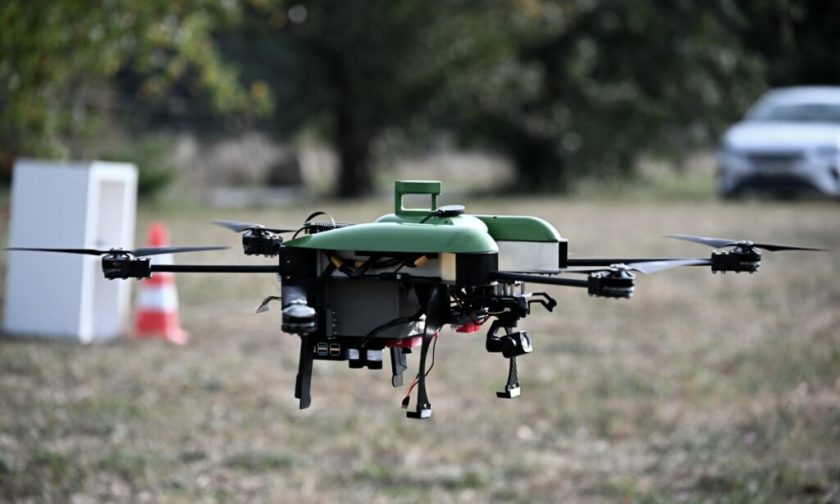
The heart of the system is a drone that takes off automatically from a drone hangar. This hangar, developed by Chemnitz University of Technology, is already in the drone’s operational area at Lake Partwitz. The MINTMASTERS drone, which can reach speeds of up to 85 km/h, not only takes off and lands automatically in the hangar, which opens automatically before the mission, but also flies on a specially defined, safe path to the operational area. All possible flight trajectories have already been pre-calculated by the TU Dresden. The quick opening of the hangar (5 seconds), the drone already in standby and the fastest route to the operational area play a crucial role in water rescue: the time saved helps save lives in an emergency.
The target area is determined by the responsible control center based on an emergency call received reporting a person in distress in the water. In parallel to the traditional alerting of the water rescue service or the responsible fire department, the control center now also automatically sends the drone to the operational area. This only happens after an emergency has been identified and not as a preventive measure.
The sensors installed on the drone not only ensure trouble-free flight, but the images taken by the camera system are analyzed by an AI algorithm specially trained at the BTU Cottbus-Senftenberg (BTU). The person in distress is identified via a neural network trained with large amounts of video material. The defined search patterns are also crucial here, as they help to find the person not only as quickly as possible, but also in a flight at defined altitudes that saves energy for the drone.
As soon as the person is identified with sufficient accuracy, the drone approaches the person and can drop up to two floating objects weighing 200g each next to the person or next to people coming to help. These floats inflate automatically when they come into contact with the water and then serve as a swimming aid for the injured. The drone then remains above the person in distress in order to guide the arriving rescue workers precisely to the scene. Once these forces arrive, the drone returns to the hangar and lands.
After the hangar is closed, a post-flight inspection is carried out in it, which uses both telematics data and camera recordings of the rotors to look for any damage. If the check is completed successfully, the RescueFly system reports to the control center that it is ready for use again.
As part of the overall project managed by the Brandenburg Institute for Society and Security (BIGS), emergency call columns/emergency telephones (NRT) were also set up on the lakes by the Björn Steiger Foundation for validation purposes, and antenna systems were installed in Welzow and Laubusch by the company DRONIQ. These antennas, in conjunction with the “hook on device”, an LTE transponder developed by DRONIQ, enable the drone to be (digitally) visible in the control center. Furthermore, the sensor technology mentioned enables other air traffic participants to see the drone, which means that air traffic can be safe for all parties. In order to make the RescueFly system transferable to other regions, the selection of the optimal locations for the hangar, the NRTs, the antennas as well as the probabilities for possible areas of operation were made exclusively on the basis of open data. All systems used are characterized by a consistent open source approach that simplifies further developments.
As required in Germany, the entire flight of the drone was monitored by a remote pilot in order to be able to intervene immediately if necessary.
For more information visit:
www.droniq.de
