By Chris Stonor
April 29th, 2019 may prove to be a decisive date for the UK’s Maritime & Coastguard Agency (MCA) as well as the Royal National Lifeboat Institution (RNLI), for drones swooped in to help improve their search and rescue abilities as new technologies continue to make the seas and coastal areas safer. The drones are being trialled along the Essex coast in a year-long programme instigated by the county’s police force who are UK pioneers in the employment of unmanned air systems (UAS).
Paul Eathorne, Aviation Requirements Lead at MCA says: “The beneficial use of drones is key. We are limited by their capabilities and the regulations surrounding them, so most of the work is about locating missing people and those in danger around the coastal areas by using the thermal imagery and optical zoom camera technology on-board.” He continues, “UAVs can fly in to the nooks and crannies and problematic areas of coastal regions which helicopters have difficulty accessing. This can help us locate people more quickly and easily.” This is also cost-effective as helicopters are expensive to fly.
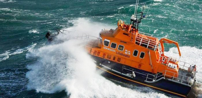
HM Coastguard Teams from Walton, Clacton, Mersea Island, South Woodham Ferrers, Southend and Canvey Island are taking part, supported by a range of inshore and all-weather lifeboats and hovercraft strategically placed at six RNLI stations along the county coastline.
Essex Police Drone Manager, Perran Bonner says: “We are delighted to be supporting this trial. Our drone team are available to assist both organisations by providing a live view of the county’s coast and investigating any suspicious behaviour, responding to welfare concerns or searching for a missing person. The technology available to us and the expertise of our officers mean we can provide accurate and up-to-date information to the relevant people, ensuring that a quick and appropriate response can be taken.”
Will Roberts, Senior Innovation Manager at the RNLI, says, “The situational awareness that drones provide can play a significant role in helping us locate casualties more quickly. When lives are at risk, the speed at which our lifeboat crews can locate and reach a casualty is vital. It also allows potentially dangerous situations to be risk-assessed before our teams are deployed to the scene.”
https://www.youtube.com/watch?v=VZJQckMNCzQ

Will Roberts
But technical and regulatory restrictions are, at the moment, limiting the potential benefits that drone might eventually bring to SAR maritime agencies.
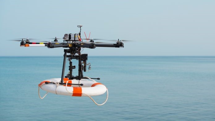
The capability of drones used by the emergency services remains fairly basic due to their high cost. They are not all-weather, yet, so can only be employed in dry conditions. The vision of flying them off the bows of lifeboats out at sea in choppy waters is presently not feasible. The UAV battery-life is also short, no-more than 20 to 30 minutes at best, so the hope is, that as costs come down, search and rescue (SAR) will be able to invest in drones with better capability. Then there are the governmental regulations. At present, they cannot fly higher than 400 feet and must remain within sight of the operator. While there are special exemptions when saving people’s lives, the risks involved must be stringently appraised as safety is paramount given the very busy UK aviation skies.
Another beneficial area for the use of UAVs is after severe weather.
Eathorne says: “Drones can help especially with flooding, whether around coastal regions or after rivers have burst their banks. They offer live video feed to those involved in the clear-up operation and can locate people in difficulty.”

Paul Eathorne
Police Sergeant James Rees, Drone Team Manager for Dorset, Devon and Cornwall Police, says, “We are in regular contact with the MCA and RNLI and were part of the initial Essex evaluation discussions, but took a step back because our region is far larger. We’re following this trial with great interest and if successful may well follow suit.”
Will Roberts is optimistic about the future use of drones for the RNLI.
“There are various new ways in which they could be employed,” he says. “One potential option is to have a tethered drone on a lifeboat. It need be no-more than 100’ high above the boat. This offers an increase height of eye. With on-board image processing technology, the drone would be tasked to detect and identify objects of interest in or around the water. The data along with relevant imagery could be then transmitted live to any SAR coordinator in the area.”
This confirms Roberts view that the primary future role of drones for SAR operations will be as data collectors.
“Swarm technology is one possible aspect of this,” he continues. “Each class of UAV offers different benefits. For one operation you may have multiple drone classes being tasked for different intentions. To avoid collision they must be safely managed and integrated within a particular airspace. This also ensures the search is carried out in the shortest possible time.”
While Roberts can’t foresee drones taking off from lifeboats, quite yet, he points out there is technology being created to allow them to land on unstable platforms. Also, in the future, they may have all-weather marinisation systems and a battery-life sufficient for a search to be conducted safely and effectively.
“I believe we’ll eventually see a democratisation of drone design,” he continues, “Where each emergency service will deploy bespoke unmanned vehicles for their particular practice.” Roberts concludes. “Most importantly, we should not push technology where and when it is not wanted. We need to be responsible at every step and question, does this add value? Does it make our SAR operatives safer? Will this save life?”