To ensure the safety of aircraft and comply with international regulations (such as ICAO Annexes 14 and 15), internal legislation established by the CAA mandate that airports and ANSPs identify, evaluate, and mitigate air navigation obstacles in the vicinity of an airport. There are still numerous challenges associated with their management such as properly identifying them, accurately evaluating risks and balancing safety with operational efficiency. In addition, there are also some struggles that ANSPs and airport operators face with providing eTOD datasets, such as high costs of implementation and maintenance, lack of standardization across different countries, and difficulties in integrating the eTOD data with existing systems. Moreover, due to dynamic changes in cities’ skylines and rapid growth of UAV operations, the need for a reliable digital terrain model source is more likely to grow significantly in the future.
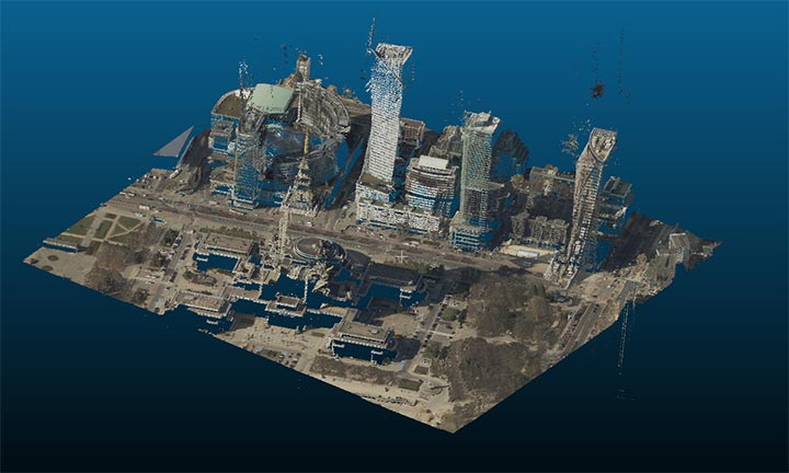
To address these issues, a new Automatic air navigation obstacles monitoring system named SAMPLE[1] is being developed by a Polish consortium formed from the Polish Air Navigation Services Agency (PANSA), AP-Tech and Creotech Instruments. SAMPLE is an innovative system which utilizes cutting-edge technology to automatically derive accurate data on air navigation obstacles (and terrain) based on high-resolution Earth Observation satellite imagery and supplementary data for further advanced visualization, risk analysis, reporting and automatic notifications.
As a result of the R&D activities, SAMPLE is a system equipped with an innovative mechanism for efficiently processing multi-source data and providing a digital terrain model and other complex sets of information on objects and their parameters for a given area. Depending on the nature of the final customer (ANSP, CAA, airport operator, UAV operations manager, LAU, real-estate investor etc.) SAMPLE as a system allows the selection of required input data and the formatting of output data.
The innovativeness of this breakthrough solution lies primarily in its ability to integrate data from multiple sources generated using various technologies. The basic set of input data includes satellite images, Synthetic Apperture Radar images, Point Clouds, video surveillance and UAV scans including photogrammetric and LiDAR products. Furthermore, additional information such as NOTAMs or air navigation obstacles databases from local ANSPs can be added and cross-checked.
In accordance with what was mentioned above, products generated by drones can be used as sources of data in SAMPLE analysis. Specifically, drone flights in this project are used to generate precise point clouds. This allows for increased accuracy of the final products such as reliable digital surface models and supporting urban air mobility.
Novel Machine learning and other proprietary AI techniques are implemented in the analysis process to detect, measure, and categorize objects, as well as to anticipate the emergence of new air navigation obstacles (for example, tree growth analysis and prediction). Very complex analysis of a large area can take a few seconds to several hours, which is significantly faster than traditional field surveying methods. Moreover, the system lowers the cost of data acquisition and increases its overall availability.
The outcome of the analytical process is basically a digital terrain model providing information regarding all objects with the source data resolution. The output data can be provided to the customer in various formats, including AIXM 5.1, custom database or API, air navigation obstacles survey or a digital terrain model. SAMPLE can provide the documentation needed to report air navigation obstacles to the CAA and even execute such a report autonomously. Taking into account the ongoing formation of regulations for vertiports (including the 2022 EASA document “Prototype Technical Design Specifications for Vertiports”), the possibility of analysing obstacles for the limiting surface of any applied FATO (Final Approach and Take-Off) for VTOL-capable aircraft is also considered. This includes considering the surfaces for approach, take-off climbs and transition in the design of vertiports.
Air navigation obstacle data provided by SAMPLE complies with all formal requirements concerning integrity, resolution, and accuracy (considering the minimum confidence level specified in ICAO regulations for vertical and horizontal measurements). Achieving such high values for these parameters is possible due to the fusion of different high-accuracy data that cross-validate each other. The operational readiness of the system is being validated by the Polish ANSP – PANSA.
SAMPLE’s automatic analysis can be performed at any requested time. The system identifies air navigation obstacles based on the dimensions of the OLS defined in ICAO Annex 14, eTOD defined in ICAO Annex 15 and can also analyse any surfaces required by the customer. This allows flexibility in adapting to future regulations and analysing other restricted areas (such as BRA).
SAMPLE, in addition to its basic functionality, also involves several complementary modules. One of them is ARESS (Airfield REmote Safeguard System), an advanced system installable at an airport to detect real-time presence of air navigation obstacles within the runway approach surface. This module is primarily designed for instantaneous real-time temporary obstacles detection. It uses a dedicated optical system to provide a comprehensive analysis of objects within an 18 km range. Detected objects are automatically classified and stored in the SAMPLE database.
During the development process, SAMPLE consortium members regularly consult with the Polish CAA to ensure that the system’s output meets all formal requirements and are practically useful for the CAA, ANSP and airports. Furthermore, a meeting between the SAMPLE project consortium and representatives of all the Polish airports took place in Warsaw in January 2023. The goal of the event was to present the project concept and adapt the final product’s assumptions to the real needs of the customers like airport operators. It is assumed that SAMPLE can successfully support, modernize or even replace the current processes for detecting and cataloguing air navigation obstacles in the future.
SAMPLE provides a 3D representation of the analysed terrain along with any obstacles, such as buildings and trees, present in a given area of interest. This information can be used to plan the flight path of a UAV ensuring that the aircraft avoids any obstacles and stays within safe-flying constraints. Additionally, the obtained DSM or UAM products can be used to determine the best location for a UAV to take off and land and to plan the most efficient flight path for a specific mission or task. Furthermore, SAMPLE can help in generating the 3D maps and fly-through simulations as well as determining landing zones and take-off points for the UAVs. The ability to obtain a digital representation of a specific terrain is also crucial for the implementation of autonomous drone traffic in both closed environments such as airports and smart cities as well as any open areas. Moreover, the previously mentioned capability of predicting changes enables long-term planning.
Therefore, entities that use drone technology can both be collaborators (supplementary source of data for analysis) as well as recipients of system’s products. The system’s creators expect that the of the service will be comparable to the expenses currently incurred by airport operators in order to effectively manage air navigation obstacles around the airports, including commissioning surveys and creating detailed documentation. It is anticipated that the main SAMPLE services will be available for users in Q4 2023.
![]()
Project is co-financed by the European Regional Development Fund of the European Union under the Smart Growth Programme 2014-2020.
For more information
info.sample.aero/en/
[1] SAMPLE – pl. System Automatycznego Monitorowania Przeszkód Lotniczych i Ewidencji