The 2020 African Drone Forum invites Unmanned Traffic Management (UTM) service providers to submit an expression of interest for the African Drone Forum due to take place in Kigali, Rwanda, 5-7 February 2020. The Forum is a multi-stakeholder engagement programme taking place in a country already using drone technology to improve the lives of its citizens. The event will showcase the latest drone technology, convene experts and regulators together in a symposium, and challenge drone companies to take part in flying competitions with real-world elements.
In an effort to support and accelerate UTM integration, the African Drone Forum will facilitate discussions between African civil aviation authorities and UTM service providers and allow demonstrations of service provision using drone data from the Lake Kivu Challenge (LKC) Flying Competitions. Eligible UTM companies will display their technology and services using live data from the LKC flying competitions.
As the number and complexity of drone flights increases, several conditions will be necessary to foster safe, secure, efficient, affordable, and resilient operations, in either segregated airspace or through integration of drones in national airspace systems.
Services can include some or all of the following (from the draft EASA opinion on U-Space Regulation, RMT.0230: high level regulatory framework for the U-Space):
- E-identification service;
- Geo-awareness service;
- Flight authorization service;
- Traffic information service;
- Tracking service;
- Weather information service; and
- Conformance monitoring service.
Minimum UTM requirements include live drone tracking through Remote Identification (Remote ID) via either direct broadcast1 or network publishing2 to allow integrating a range of Remote ID options such as:
- ADS-B; using uAvionics Ping 1090i and pingStations;
- Low-Power Direct RF, Unlicensed Integrated C2;
- Networked Cellular; using devices such as the Unifly BLIP;
Optional features include:
- Integration of ATM radar data or Mode A/C/S transporter;
- Remote ID via satellite;
- Low-Power Direct RF [p. 10, FAA UAS ID ARC];
- Dynamic geo-fencing;
- Separation service: strategic and tactical conflict and collision avoidance;
- Weather service integration;
- Flight planning.
Interested UTM service providers are invited to complete an online form for an opportunity to showcase technology and capabilities to key players within the emerging drone ecosystems throughout Africa at:
https://docs.google.com/forms/d/e/1FAIpQLSdtp8V9BWB0pOCbhdPenBvo1D68tuMYJdB-_jxy-mFPVIcOcQ/viewform
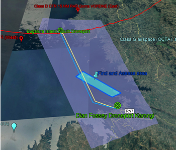
During the ADF-LKC flying competitions, two DronePorts will be located 17.6 kms apart (direct line) with inbound and outbound racetrack BVLOS routes between the two. Rural Asset Mapping data flights will operate at various locations either over Lake Kivu (where several vessels ply, especially fishing dinghies) or Bugarura Island (with some sensitive infrastructure, power lines, dense ferry routes to the mainland, and a very high population density). A restricted (segregated) airspace contains the DronePorts, BVLOS routes and Rural Asset Mapping areas. Conventionally piloted (manned) aircraft will overfly the northern DronePort and may be equipped with either Mode C or Mode S transponders. GSM coverage exists throughout the restricted airspace, and the 4G LTE is Band 20. 240V uninterruptable power will be provided. Internet will be available through a modem. A broad range of drones, autopilots and ground control stations will be utilized.
The following are considered by the ADF as future focus areas:
- Deciding when various levels of UTM will be required, for example, the technical infrastructure system and human interface components in response to increasing complexity or demand for services, and this may include registration, flight plan approval, flight consent (clearance) from ATC, multi surveillance tracking and display. An additional question is which stakeholders should have interactions with the data?
- Another issue becoming a major hurdle in providing drone services supported by UTM is the set-up and ongoing cost of the technical infrastructure system and human interface components, especially essential real-time positioning (surveillance) of both conventional (manned) and unmanned aircraft, displayed to the UTM operator in a manner that the performance of the communications/navigation/surveillance is provided, assurance that agreed routes are being followed, and that all expected flights are known. Finally, that tracking of lost link, flyaway or manned aircraft errors can be conducted as a contingency or emergency response.
- In many locations, there is no ATC radar surveillance. Also, some aircraft will be non-cooperative (no identification, no communications). Detect and Avoid/ Sense and Avoid technologies are still under development. Even when conventional (manned) aircraft in the area have cooperative surveillance (Mode C or S transponder) their position won’t necessarily be picked up by ADS-B receivers. This interaction needs to be safely managed; especially with consideration of saturation of the 1090 Mhz network. Alternatives exist (FLARM, licensed mobile spectrum: LTE, 3G/4G, SAT-COM) yet these are generally uncertified, their performance is variable, and coverage is often non-existent. Multilateration (timing of received messages differentials compared to distances from the antenna to the aircraft through trigonometry, to verify that the claimed position is close to the position from which the message was broadcast) is beneficial as this can remove errors in navigation and surveillance single source systems and detect hacking/spoofing.
- Cost-benefit: during VLOS and BVLOS flight trials in September 2018, unmanned platforms were fitted with ADS-B (uAvionix ping 1090i) and tracked through both the autopilot/GCS and ADS-B receivers. A $150 bamboo drone was equipped with a GSM tracking transmitter to highlight the present cost of identification and tracking. Sophisticated, SWaP real-time identification and flight information transmitters for UA are understandably expensive; however, a more cost beneficial system is essential.
To register an expression please visit: https://lnkd.in/gb3bd5W
(Image: African Drone Forum LKC flying competitions)
For more information visit: