Danish surveillance company Terma has augmented its SCANTER 6002 radar with advanced artificial intelligence classification designed to detect, track and classify small remotely controlled or
Read more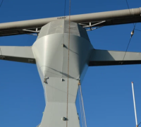
The information portal for unmanned air system traffic management (UTM) and counter-UAS (C-UAS) systems


The information portal for unmanned air system traffic management (UTM), urban air mobility (UAM), counter-UAS (C-UAS) and space traffic management systems
Danish surveillance company Terma has augmented its SCANTER 6002 radar with advanced artificial intelligence classification designed to detect, track and classify small remotely controlled or
Read more
The European AiRMOUR research project has conducted a survey of over 1,000 citizens on drones and Urban Air Mobility (UAM). The survey examined public attitudes
Read more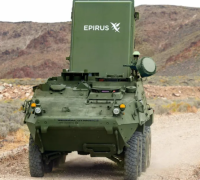
Technology company Epirus has joined with General Dynamics Land Systems to introduce an integrated mobile high-power microwave array ground combat vehicle, unveiled at the Association
Read more
The US Army has included SmartShooter’s SMASH 2000L weapon-mounted fire control system as part of its Counter small Uncrewed Aerial Systems (C-cUAS) defence. SmartShooter was
Read more
Air Mobility Consultants, IBG, in partnership with the world’s leading Unmanned Traffic Management Technology Provider, AstraUTM, will conduct Sweden’s first Intercity Drone Flight between Linkoping
Read more
Texas A&M University-Corpus Christi’s Lone Star Unmanned Aircraft System Center of Excellence and Innovation (LSUASC) designated Federal Aviation Administration (FAA) test site has received USD3
Read more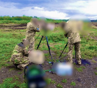
Polish drone detection company Advanced Protection Systems has supplied its SKYctrl counter drone systems to armed forces in Ukraine, according to the company’s social media
Read more
US based connectivity company Voltela has become the latest member of Drone Logistics Ecosystem (DLE), the global/virtual network of companies, universities, the public/governments, and investors
Read more
The Polish air navigation service provider PANSA and GOF2 consortium partners are hosting an Integrated Urban Air Mobility Forum at Kąkolewo, Poland on October 14
Read more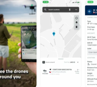
A mobile App developed by Czech company Dronetag enables users to visualise the current airspace including other participants using Remote Identification (Remote ID) data. The
Read more