


BT, together with Altitude Angel and a number of UK tech start-ups, have been selected by UK Research and Innovation to deliver a Future Flight Challenge project called Project XCelerate which plans to establish a commercial drone corridor in open and unrestricted airspace, located south of Reading, Berkshire.
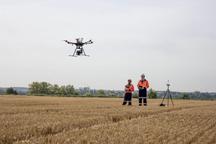
In summer 2021, the project will conduct flight trials along the 8km-long corridor to demonstrate how drones can operate safely in the same airspace as manned aviation. The consortium will demonstrate key industry use cases across healthcare, emergency services and infrastructure to illustrate how drone deliveries and inspection can benefit business, the public sector and UK citizens, says a press release from Altitude Angel.
Project XCelerate aims to widen the use of UTM systems by providing a framework which towns, cities, organisations and networks can follow in order to ‘open up’ portions of the sky. The project aims to realise commercial automated BVLOS flight zone in which any compatible vehicle can connect into and fly within safely.
Joining BT, the consortium includes drone technology experts from Altitude Angel, Dronecloud, HeroTech8 and Skyports, cyber security provider Angoka, and end user experts SkyBound Rescuer and DroneStream.
SkyBound Rescuer will be managing and delivering the emergency response trials alongside HEROTECH8, manufacturer of automation stations for drones. SkyBound Rescuer CEO Gemma Alcock said: “We will be managing the emergency response use cases, which will enable drones to reach emergency incidents ahead of rescue teams to autonomously conduct optimised mission plans based on our research-driven methodologies; enhancing safety, saving cost, saving time, and saving lives.” The two emergency response use cases that have been selected for these trials are road traffic collisions (RTCs) – to 3D map the incident for forensics to reduce road closure times, and search and rescue (SAR) – to locate missing persons faster via drones as an aerial search tool.
The key use cases which will be explored by the consortium include using drones to assist the emergency services, for example during road traffic collisions and search and rescue missions. Using 3D mapping techniques, drones can be used for forensics purposes to aid the police when responding to road traffic collisions and can also help to locate missing persons during search and rescue missions. Project XCelerate will prove how drone technology can be used to speed up response times for such incidents, helping the emergency services to improve the chances of survival, whilst also reducing costs.
The project will also demonstrate how automated drones can reduce the lead times for urgently needed medical deliveries, helping the healthcare and pharmaceutical sectors to improve standards of patient care. A further use case is key infrastructure inspection, where drones can be used to help assess damage or maintenance required for critical national infrastructure for the utilities, telecoms and transport sectors.
BT will provide the critical communications required for BVLOS (Beyond Visual Line of Sight) environments such as GPS location and remote identification, command and control, redundant geo-awareness, and live notifications (NOTAMs) sent directly to drones in-flight. The company’s reliable, secure, high bandwidth, low-latency radio and fixed connectivity mean it is ideally placed to lead the consortium. Its EE mobile network is the trusted provider behind the critical Emergency Services Network (ESN) – will support the safe commercial drone corridor.
BT will combine its experience with Altitude Angel’s leading experience in Unmanned Traffic Management (UTM) platforms, together with its operation of the Arrow Drone Zone commercial drone corridor. UTM is a key enabler to address the safe and efficient integration of unmanned vehicles into airspace. Project XCelerate will combine a network of existing and new technologies underpinned by Altitude Angel’s proven UTM platform, incorporating existing air traffic management and communications systems and augmented by new technology, such as 5G.
Gerry McQuade, CEO of BT’s Enterprise unit, said: “As drone numbers continue to rise, there is an urgent need to safely integrate commercial drones into global airspace alongside manned aviation. In showing how drones can deliver improved, potentially life-saving services to the public, we’re aiming to accelerate the adoption of fully automated drones in unrestricted UK airspace in a safe and responsible way.
“From improved mobility, connectivity, healthcare and manufacturing output, to reduced road congestion and pollution, automated drone technology will transform the quality of our lives. BT’s role in the consortium is to bring world-leading drone expertise together and to provide the secure and resilient mobile network connectivity, as well as our drone detection services. The power of EE’s 4G and 5G networks will ensure commercial drones remain connected for greater situational awareness, accurate positioning and to avoid collisions – ensuring that they can be operated safely and responsibly across UK skies.”
For more information visit: