


Swiss weather company Meteomatics is using a “specially conceived Meteodrone” to provide real-time atmospheric data that also generates increasingly reliable forecasting, according to an article published in DroneDJ. Meteodrone aims to identify changing weather conditions at the lower altitude levels in which drones operate, says the report.
“Operators of research, public, or commercial drone missions are currently vulnerable to the arrival of unexpected or premature storms, fog, low-hanging clouds, ice, or other inhospitable weather conditions that can force craft to the ground – or prevent them from taking off at all. The climactic wildcard looms as an even larger risk in longer distance beyond visual line of sight (BVLOS) flights that will be required for UAV activities to scale around the globe.”
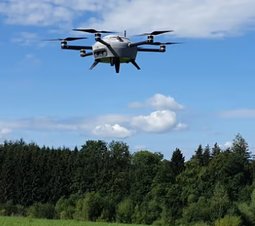
Meteodrone is designed to provide accurate real-time atmospheric data that also generates increasingly reliable forecasting.
“The system works in ways that satellites, balloons, planes, and other craft used for gathering data for metrological monitoring and forecasting can’t.
“It flies the Meteodrone into weather systems at the lowest atmospheric levels – up to 6 kilometres high – and uses sensors and video to provide localized conditions, including temperature, humidity, air pressure, and wind speed and direction. That information is fed directly to a ground station whose computer generates a high-resolution model of the current situation as well as accurate hyper-local forecasts.
“Meteomatics designed its two models of the Meteodrone to handle the kind of heavy weather the crafts’ reports seek to warn other operators about. The UAVs feature heated propellers to prevent icing, robust engines to overcome high winds and turbulence, and a parachute in case conditions bring it down.
“Though weather forecasting has become quite dependable generally, the Meteodrone was developed to fill the information gap remaining in the so-called boundary atmospheric layer – especially the zone two kilometers above the ground where drones operate, and where weather can change unexpectedly and quickly. The Meteodrone is designed to fly within this altitude and collect weather data during to improve weather forecasts, and act as a mobile, wider-ranging, and-you-are-there addition to fixed land-based meteorological stations.
“Meteodrones are operated in over a dozen permanent weather stations in Switzerland under BVLOS waivers, and have been tested in Oklahoma. The system is expected to be introduced in the US in coming months pending Federal Aviation Administration approval.
“The craft are sold with an optional docking nest allowing for regularly launched automated missions in addition to manual operation, both at day and night. Meteodrone nocturnal missions provide increased accuracy of weather conditions expected for the following day, giving a wide variety of drone operators a far better vision of where – or even if – their planned missions can be carried out.”
(Image: Meteomatics.com)
For more information visit:
www.dronedj.com