Canada’s National Research Council (NRC), in conjunction with Transport Canada and other partners, is conducting research on urban airflow. Airflow in urban centres is very different from rural settings. The close proximity of multiple buildings can amplify wind speed and create tricky – and invisible – areas of turbulence. These can cause havoc for operators, and potentially for people and property on the ground.
The NRC is looking at the unique characteristics of urban wind patterns – along with the potential challenges they pose to drone flights. Are there certain locations where increased wind speed and turbulence pose a greater risk to safe RPAS operations? What wind speeds might be deemed unsafe? Can data gathered help lead to guidelines, or even additional regulations, for operations in cities? If the speed of wind at ground level is X, might we be able to predict peak turbulence wind speeds? Might drone manufacturers have to revise their own guidelines/parameters to take these conditions into account?
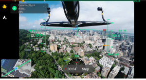
The view from the InDro dashboard, showing a wishbone-shaped appendage carrying two anemometers
Previous studies have shown that turbulence caused by buildings can indeed impact the stability of RPAS flights. Now, the NRC is keen on digging deeper and gathering more data.
The research is being carried out by NRC’s Aerospace Research Centre, in conjunction with a number of partners – including McGill University, Montreal General Hospital, CHUM Centre Hospital, InDro Robotics and others. The flights are being carried out by InDro’s Flight Operations Lead, Dr. Eric Saczuk (who is also head of RPAS Operations at the BC Institute of Technology).
“Urban environments create a variety of exacerbated micro-level wind effects including shear, turbulence and eddies around buildings. These effects can locally increase reported wind speeds by up to 50 per cent,” says Dr. Saczuk.
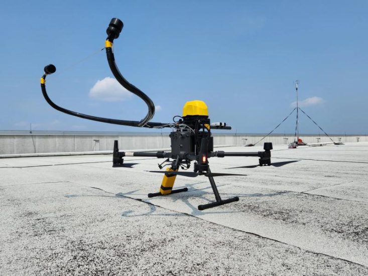
InDro has been involved with this research for three years – with earlier flights carried out in the NRC’s wind tunnel. Now, the testing has become more real-world. InDro flies a specially equipped DJI M300. The wishbone-shaped appendage in the photo above carries two tiny anemometers placed specifically to capture windspeed and variations without being affected by the thrust generated by the rotors. The drone is also equipped with an AVSS parachute, since these flights take place over people.
Some months prior to the flights, the NRC installed fixed anemometers on the roofs of the hospitals mentioned above. This allowed researchers to obtain a baseline of typical wind speeds in these areas. Then came the flights.
“Part of our mission is to fly the drone over three different rooftops and lower the drone to hover at 60m and 10m above the anemometer station,” says Dr. Saczuk.
“This allows NRC to compare the wind data recorded by the static anemometers with data captured by the mobile anemometers on the drone. Our launch sites are from the CHUM Centre Hospital and the Montreal General Hospital, which are about three kilometres apart with a pilot at each location. Additionally, we’ll be flying the drone from one hospital to the other and also along an ‘urban canyon’ between the three rooftops.”
Challenges
Flying in urban locations always requires additional caution. The research also demands very precise altitudes while capturing data – along with piloting with the anemometers attached to the drone.
“Gathering the data always has its challenges – especially when operating over a dense downtown core such as Montreal,” he says.
“Many months of planning led to two days of successful data capture on July 26 and 27. One of the main challenges is maintaining C2 connectivity amongst the tall buildings. Another consideration is ensuring a proper center of balance with the added payload well forward of the aircraft. Resultingly, flight endurance is shortened due to the extra load on the motors and thus we had to modify our flight plans to account for this. We learned a lot during the first two days of data capture!”
The National Research Council is helping to prepare for the future of Urban Air Mobility. As part of its seven-year Integrated Aerial Mobility program (launched in 2019), the NRC has already been working on developing related technologies, including:
- “optical sensor-based detect-and-avoid technologies to assist path planning of autonomous vehicles
- “drone docking technologies to support contact-based aerial robotics tasks
- “manufacturing of high-density and safe ceramic lithium batteries to enable low-emission hybrid-electric propulsion”
The view from the InDro dashboard, showing a wishbone-shaped appendage carrying two anemometers
(Image: A DJI M300 drone, modified by InDro and specially equipped with anemometers to detect windspeed while avoiding prop wash)
For more information visit: