


Drone operator IN-FLIGHT Data partnered with remote traffic management software leader AirMatrix to repeat an Uncrewed Traffic Management (UTM) project first carried out in 2022 to conduct an urban signals mapping operation. The operation was carried out almost 1,000ft above the ground, beyond the line of sight of the pilot, and over urban neighbourhood populations.
The operation represented a successful SAIL 4 mission, referring to the regulator’s combined complexity of a drone mission, from 1 (low) to 6 (high).
Since Phase 1 of the project in 2022, IN-FLIGHT Data and AirMatrix have been testing, training and preparing to conduct a much larger advanced RF survey in Calgary. Completed in partnership with The City’s Smart City Living Labs Program, The City’s aim is to offer access to city assets for companies, researchers and individuals to test and try ideas and products in a real-life environment, helping entrepreneurs bring big ideas to fruition and supporting investment in the local economy.
According to the IN-FLIGHT press release, Phase 2 of the project flew for 660 km entirely inside the City of Calgary, with a population of about 1.4 million people, under approved SFOC. Most times, the aircraft was over 2 km away from the pilot while performing the high aerial survey. Utilizing a highly-trained air crew working with advanced and certified drones and the latest in aerial surveillance technologies, including hardware and software, the purpose of the aerial intelligence gathering was to scale-up the measurement and assessment of the entire communications network fabric above Calgary, including geolocation, cellular, radio and many others.
This understanding of urban radio network performance is required to support future advancements in aviation. For example, the FAA in the USA recently announced the approval of flying taxis by 2028. This project supports the development and growth of these technological advancements in transportation and mobility, including aircraft such as Uber, Archer or Joby.
Telecommunications companies, governments, regulators, airspace navigation service providers, and industry are all needed to understand how high-performance drone aircraft will safely navigate and communicate in the air above population centers. Think of it like when the Canada Railway was built in the 1800’s – someone came before the rail lines to survey the route, level the land for the rail ties and dig tunnels through mountains. That’s what this project achieved at-scale – successfully 3D mapping the urban network fabric to understand and assess how future aircraft and infrastructure can take advantage of these new high-performance networks to deliver future innovation to the cities and their citizens.
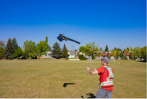
(Image: IN-FLIGHT Data’s SAIL 6 urban flight operations using advanced drones certified for flights over people in a major urban center. Photo credit: Droto.ca)
For more information visit: