



By Philip Butterworth-Hayes
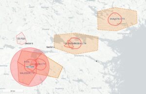
The Swedish Transport Agency (STA) has approved the establishment of a temporary D-area and associated geographical UAS zone in Norrköping, allowing the Swedish Police Authority to conduct beyond visual line of sight (BVLOS) operations with automated “drone-in-a-box” systems within controlled airspace (Norrköping CTR) – a first-of-its-kind solution in Sweden, and potentially a model that could be applied at other control zones where there is a demonstrated need for BVLOS operations before U-space becomes available, according to the agency.
“The decision enables police UAS operations up to 120 m AGL and is intended to support, among other things, situational awareness, crime prevention and incident management,” said Christoffer Massinger, State focal point & U-space specialist at the Swedish Transport Agency. “What makes the case particularly interesting is the way the airspace has been designed. The D-area was developed through local coordination with the airport stakeholders, ATS and other relevant airspace users, with the aim of designing a volume that enables the operation while minimizing its impact on other aviation. Meanwhile, a geographical UAS-zone that correlates with the D-area has been designed to limit/restrict access to other UAS-operations above 79 meter AGL, to give the Police authority an exclusive right of way between 80 and 120 meters AGL. The D-area does not exclude manned aviation; instead, specific conditions and coordination procedures are used to balance the rights and responsibilities of different airspace users and to enable coexistence. ATS will be able to perform their duties while the Police is operating in the area.”
The STA published a number of conditions to be applied to police drone activities within the new zone (see Conditions for establishing a D-area).
According to agency’s decision statement: “The Swedish Transport Agency considers that the Swedish Police Authority has demonstrated a concrete and urgent operational need to conduct BVLOS operations. The temporary D-area and the geographical UAS zone are, according to the Swedish Transport Agency’s assessment, necessary and proportionate measures to enable safe coexistence between manned and unmanned aviation. The restrictions are limited in time and geographically and do not go beyond what is required to achieve a sufficiently high level of flight safety while ensuring continued access to the airspace for other airspace users under orderly conditions.”
“From our perspective, D-areas are therefore an important step on the way towards U-space: we need practical solutions today, rather than waiting for the full U-space framework to be operational,” said Christoffer Massinger. “The decision explicitly recognizes that temporary airspace segregation can be necessary to enable safe BVLOS operations, while also emphasizing proportionality and continued access for other airspace users.”
| Conditions for establishing a D-area
1. If the Swedish Armed Forces have a need to temporarily establish a restricted area that overlaps parts of the danger area, the activities of the Swedish Armed Forces shall have priority. The activities of the Swedish Police Authority within the danger area may then continue outside the lateral and vertical boundaries of the restricted area. If the boundaries of the restricted area overlap the entire temporary danger area, the danger area shall be deactivated and the activity may not be conducted. AMC Sweden is responsible for contact between the Swedish Armed Forces and the Swedish Police Authority. 2. The Swedish Police Authority shall ensure the ability to communicate the status of the activity in the danger area in an appropriate manner, through: a. Contact telephone. One or more telephone numbers for the responsible coordinator shall be available to airspace users. These numbers shall be continuously staffed while the danger area is activated. b. Monitoring on VHF 120.355 & 132.955. The ability to listen to nearby activities, and where necessary communicate the status of its own activity in the area, may be fulfilled through the use of aviation radio outside Norrköping ATS opening hours. Use of aviation radio may only take place after a transmission permit has been obtained from the Swedish Post and Telecom Agency (PTS), and authorised personnel hold a certificate of competence to transmit on aviation radio. 3. The Swedish Police Authority shall ensure that the following characteristics and capabilities are available, function reliably, and are used by the remote pilot flying in the danger area within the scope of its own activity: a. ADS-B IN receiver. b. Correct altitude data and altitude references. c. Geofencing technology ensuring that all flights take place within the boundaries of the danger area with associated vertical and lateral buffers. d. Continuous monitoring of its flights in its own systems and, in the event that other aviation is present within the area, taking measures to minimise conflict between aircraft. 4. The Swedish Police Authority shall ensure that the activity within the danger area can be immediately terminated when required to maintain flight safety, or when instructed to do so by air traffic control. Conditions for geographical UAS zone 5. The Swedish Police Authority shall ensure the capability to administer and manage the underlying geographical UAS zone ESU267 Norrköping City. Administration and management means the capability to grant/deny permission when an operator other than the Swedish Police Authority wishes to conduct UAS operations within the restricting geographical UAS zone at heights above 79 metres AGL, in cooperation with Norrköping ATS during its opening hours. 6. For UAS flight above 79 metres AGL within the geographical UAS zone ESU267, permission from the Swedish Police Authority, as well as Norrköping ATS during Norrköping ATS opening hours, is always required in accordance with the conditions for the applicable geographical UAS zone |
For more information
LFV – Drönarkartan (RPAS, UAS, UAV)
(Image: Norrköping – Shutterstock)