


One of world’s first national operational UAS traffic management/air traffic management (UTM/ATM) systems to coordinate drone flights in controlled airspace and to support drone pilots in all areas of a national airspace, was operationally launched on the morning of 2 March 2020 when 124 flight plans for drone missions were filled and approved using the PansaUTM system in Poland. The initial service covers just three of the country’s 14 air traffic control towers but is being gradually rolled out in all TWRs and five flight information sectors covering the whole country during 2020. Unmanned Airspace talked with the key representatives of PansaUTM team: Maciej Włodarczyk – Head of UAV Operations Department; Filip Sosin, Manager of PANSA U-space Programme; Mateusz Kotliński, PansaUTM Project Manager; Rafał Paprocki, PansaUTM test coordinator; Paweł Korzec, PansaUTM Solution Architect and DroneRadar CEO
What is the history of the drone industry in Poland?
Maciej Włodarczyk PANSA has a long tradition of UAV flight coordination. The first drone legislation was introduced in 2013 but the age of the consumer market began well before then. PANSA recognized drones as new airspace users right from the beginning and started to adopt bespoke solutions and procedures to the growing needs of the entire industry. This is how Poland’s air navigation service provider (ANSP) managed to gain the trust and cooperation of the new community of aviation users. Poland has always been a drone friendly country and our solutions were innovative – starting from national legislation through to PANSA’s operational solutions as they related to effective, safe coordination of UAV flights. The next, obvious step was to implement an UTM solution.
Filip Sosin Our published information and data are facts based on accomplished achievements. This is not some kind of “fake news” or PR-oriented information which is far from the truth and it’s not a far-reaching plan for which there are no particulars.
Let the following figures be treated as facts confirming both the operational deployment of PansaUTM and the many years of hard work of state and private institutions in building a high level of awareness among the new airspace users, the drone pilots. This includes unique legislative solutions regulating UAV flights in Poland since 2013, more than 100 drone pilot training centres, over 14,000 drone pilots and a social campaign. The initial PansaUTM trials involved the cooperation of 6,000 registered drone pilots and nearly 200 controllers who have now been trained to operate the system. The numbers of users are growing even more now.
What were the biggest challenges to bringing PansaUTM into operation – technical, certification, institutional?
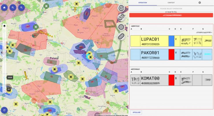
Mateusz Kotliński Bringing any IT system into operational use in the ATC environment is always a challenge. The UTM implementation had an additional burden of being an innovative solution. The handicap was to keep a balance between enterprise governance and user functionality, while instantly changing the roadmap. The system might be intuitive to use for the users, yet from the technical point of view it’s a complex process. (See box: PansaUTM – what it comprises and how it works). There are different modules for different users and every module is linked to each other so requests from drone operators to controllers can be assessed in a streamlined way. A crucial element within the system is the collaborative ATC interface – the Controller-Drone Data Link Communication (CDDLC), an innovation in the U-space world, based on well known in manned aviation Controller-Pilot Data Link Communication (CPDLC) technology. The most important issue was to assess all aspects in terms of safety. We cooperated closely with the CAA to check and demonstrate that all the critical barriers and contingency measures are in place. Making safety the priority (with all the effort that this costs) is one of the reasons for success of the project.
Maciej Włodarczyk The other challenge was to ensure that the conversion of flight coordination into the digital process met the certification criteria of the CAA. Manual coordination of drone flights in controlled airspace has been in place for many years and this gave the system designers an insight into the PANSA’s signature Airspace Assessment of the CTRs which shows which UAV flights might produce a conflict with IFR procedures. In 2018, around 10,000 flights were conducted in airspace around airports, which resulted in a heavy workload for controllers and supporting staff who had to process each application via the telephone lines and paper based pre-tactical flight conditions. The whole process of this coordination was digitised and transferred to PansaUTM.
Rafał Paprocki We began accreditation of PansaUTM in the end of 2018, with internal tests performed by specialists from the UAV operations department lasting for over half a year. Our knowledge of ASM and ATM programmes resulted in customisation of U-space requirements in the system and the user experience which was very important for us. We installed the system in Poznan tower and FIS Gdansk for operation by real users and carried out simultaneously tests by all users of PansaUTM – drone pilots, UAV operations department specialists, ATS staff – to show the system was ready for operational use.
What has been the reaction of air traffic controllers to the concept?
Mateusz Kotliński Obtaining acceptance from the ATS staff is one of the major issues when you try to introduce new solutions into the ATC workplace. However, PANSA involved air traffic controllers in the loop of drone operations coordination right from the start. The whole ecosystem was not built in one day, ironically – deployment of the system resulted in reducing the workload and ATC is very keen to conduct the UAV coordination via PansaUTM. Our project team consists of representatives of all TWRs and FIS sectors in Poland. The engagement of the operational staff was always a priority to ensure that interfaces and procedures met the needs of the end-users. We also introduced a train-the-trainer scheme which means that controllers who were in our project team became responsible training personnel in their units.
What about the drone pilots, what was their response?
Maciej Włodarczyk In parallel to the technical work involved in implementation, we launched a major social media campaign. From a single Facebook post we received thousands of reactions from pilots who wanted to use PansaUTM. We had to field these questions by telephone but the process helped us to gain trust with the pilot community. We started with an assumption that users would have zero knowledge of aviation and we have carried this philosophy through to the design of the apps, with simple yes/no answers to location and other queries. Thanks to that approach, the system is suitable for recreational and professional users.
How will the system be financed, maintained and developed?
Mateusz Kotliński For the moment, all services are provided free of charge to drone operators. Our priority has been to support safety – for drone and aircraft pilots. Safety drove our operational model but we will be thinking about providing some kind of revenue stream in the future; but first we will need to understand how drone operators react to the system and then we will assess the possibilities of self-financing. The final model depends on different issues, including the European U-space regulatory framework which is being shaped as we speak.
Are you developing any system to monitor unregistered drones?
Rafał Paprocki The system will also assist security agencies in identifying rogue drones. If security officials or authority representatives see a drone flying, they can use the PansaUTM system to see if a flight plan has been authorised in a place where it is mandatory. If it is not, the drone flight will require a security response. It is an equivalent of the white list and black list. In PansaUTM we focus on the white list, the black list needs the ability to provide direct identification from the drone. Before that happens we will need to have manufacturers involved in developing the standards and broker the information. The world is not there just yet. However, the system is fully capable of accommodating this process when the standard is ready. But this is our take on identifying possible rogue drone flights – through the flight authorisation process.
Paweł Korzec The PansaUTM team is aware that this is just the start – that tracking and identification will need to be added to the network at the next stage and then more complex drone operations thereafter. Operational tracking and standardised e-identification will solve two problems – privacy and location in the airspace. That’s why DroneRadar is working with the 5G!Drones European research programme, where we are developing a recommendation on how the process of flight planning and flight performance should be evaluated within a 5G network based on the knowledge we’ve gained from our UTM work. It is extremely important that we connect these two worlds. We believe that one day the telecommunication operator will be able to provide data for flight planning, planning HQ video transmission information, and for analytics. It will also be integrated in the UTM system for specific operational risk assessments (SORA). The risk assessment will depend on which stages of the flight will be connected to the 5G network and that will allow the CAA or ANSP to define the separation distances between drones.
Unmanned Airspace: Do you have any experience in live tracking of drones already?
Mateusz Kotliński The PansaUTM team has started to work on remote identification services to be integrated into the current system and already has access to a certified real-time database where the new data sources can be aggregated. These new sources could come from automatic dependent surveillance – broadcast (ADS-B, FLARM, OGN) information, ASTERIX or other e-identification/ tracking sensors. PANSA has begun work to test drone tracking via ADS-B, using on-board transceivers and ground stations to track drones within the UTM system. We need to assess if this method is capable of showing us the tracks in a city environment and how reliable its coverage might be. We don’t know what the future holds but some day if you want to fly BVLOS, for example, with cargo, you might need to have this tracking method on board. Once we have the operational and reliable identification from tracking then through the real-time database we will make the de-confliction possible at a tactical level which will enable more and more advanced drone applications, improve capacity and scalability of the operations.
What are other key capabilities of the system?
Filip Sosin The PansaUTM system has been developed to ensure that all the aeronautical data which is distributed to the users is certified and comes from a reliable source. The operators can check where they can fly and under which conditions. The system supports flexible use of airspace (FUA) visualisation; we combined static and dynamic data related to UAVs from different sources including NOTAMS, and all the data is updated in real time on the screen to controllers and drone pilots.
Paweł Korzec The system has been configured to support both VLOS and BVLOS flights and automatically checks to see if the drone operator has received all the necessary approvals from the CAA for the flight. And it has also been integrated with an ACM, Automatic Capacity Management function, which will allow flight requests in certain conditions to be answered automatically depending on the flight plan and any potential conflicts identified at an early stage. The AMC function is fully customisable and depends on the decision of each ANSP. In Poland, the functions is being configured on the basis of years of experience to filter the operations to those which could be approved automatically, and those which require ATC attention. This will allow us to reduce controller workload by 75% without compromising the safety.
Having launched PansaUTM what are the next milestones in its development?
Maciej Włodarczyk The team has developed the set of APIs so that any UTM service provider could connect to the system after obtaining PansaUTM certification. But there will need to be clarity from EASA as to the roles of technology providers and UTM service companies before this can be used between other UTM/CIF/FIMS systems operationally.
We are preparing the system now to make this possible but it will need to be certified by the CAA and this will be a tough challenge. We need to define exactly U-space comprises Does it mean that there are a number of U-space providers in one place, if so who would be responsible for the data provided and to ensure its reliability?
Mateusz Kotliński We are waiting for the clear U-space requirements. However, our next steps will be focused on more advanced solutions. We all know about futuristic urban air mobility visions and we all need to be aware that to achieve these, we need to solve the basics, create the fundamentals and accommodate what we already have in our airspace – small drones. Air taxis and more complex use of drones will come and UTM will be there and ready to implement them. In Europe we need to act now to transfer all drones into the “white list” so cooperative drones can be identified not only to preserve safety of manned aviation and people on the ground, but also to preserve the safety of future passengers carried by drones. That is why we see U-space in Poland as a set of fundamental services in place ready to be implemented with other services. This is where the open market, start-up companies and R&D projects can flourish. New services should fill the possible gaps and complement the ecosystem with additional services and technical standards. In PANSA’s opinion it is the only way to help U-space develop in the pace aligned with the market demand for desired frequency and type of drone operations.
Filip Sosin I sympathize with our colleagues from other ANSPs and other entities who are just beginning their process of UTM solutions implementation in their countries. We wish them a lot of determination, patience, reasonable schedules and numerous resources and of course a little of luck.
| PansaUTM – what it comprises and how it works
The PansaUTM system allows for fast, digital, non-verbal communication between air traffic controllers and drone operators. It enables drone operators to check flight possibility in a given area, digitally submit a flight plan and obtain permission to fly if it does not threaten the safety of aircraft. For air traffic controllers, PansaUTM provides information about drone flights planned in the vicinity of international airports (CTRs) along with simple authorisation/non authorisation tools. The controller has also dynamic geofencing tools and can create alert zones which would order drone pilots to land in a given area. In following months the system will be installed in all 14 TWRs and 5 FIS sectors covering whole Poland. Flight coordination takes place in a dynamic, electronic way, using PANSA’s proprietary operational solutions and the system part provided by the technology partner HAWK-E and integrated with Droneradar, the most popular flight planning app among drone operators in Poland. Drone operators request authorisations via the drone Flight Planning System (dFPL) which allows for the fast authorisation of flights through different airspace zones managed by different airspace authorities. PansaUTM is deployed within the Microsoft Azure cloud managed by PANSA. Communications are conducted via a Controller-Drone Data Link Communication (CDDLC) network, the drone equivalent of the CPDLC system. This allows PansaUTM to communicate with the drone pilot. At the moment flight authorisations and separation standards are based on procedural control principles. But system has flexibility built-in so when Eurocontrol or the European Aviation Safety Agency or ICAO adopts an airspace classification table – defining exact X,Y,Z classification of airspace for drones and which distinguishes between sectors where procedural control and radar control protocol will manage traffic – it will be possible to input these quickly into the system. The system also allows for different organisations to take responsibility for managing a sector of airspace. Three different classes of airspace management can be accommodated – with a few clicks a Local Administration Unit (LAU), such as a city or national park can define its area of responsibility – allowing for input of obstacle data from local sources, for example – with drone flight authorisation data shared through a common interface. Developing this flexible, integrated, layered system with aeronautical data from different sources but collated into a single system provided to be one of the complex challenges. PansaUTM figures 01-20 March 2020 (Since operational implementation): · 303 digital flight plans submitted for UAV operations via dedicated dFPL module – this number includes only 3 out of 14 TWRs but by the end of the month PansaUTM will be implemented in another three TWR’s and one of five FIS sectors covering nearly one quarter of uncontrolled airspace in Poland. · 135 UAV flights coordinated with TWRs via CDDLC – part of PansaUTM dATS module · 9,000 voluntary check-ins by drone pilots which gives over 300 per day (with a record 850 in one day). These are check-ins which do not require approval by PANSA. · Nearly 6,600 PansaUTM registered drone pilots · Nearly 200 ATS Staff including controllers who have been trained and are ready for operational work on the system. |