


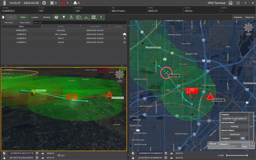
Kongsberg Geospatial, developer of the IRIS Terminal and IRIS GCS airspace deconfliction systems, has partnered with Echodyne, the radar platform company, to accelerate and extend Beyond Visual Line of Sight (BVLOS) operations for Advanced Air Mobility (AAM) applications. The collaboration will provide additional situational awareness to Unmanned Aircraft System (UAS) operators by visualizing all airspace movement, cooperative and noncooperative, to ensure safe and reliable UAS operations.
IRIS Terminal, now in its second generation, has been adapted from its defense origins to the enterprise UAS sector for visualizing airspace traffic, as well as controlling uncrewed systems in its GCS format. Ownship, cooperative, and non-cooperative traffic are all captured within IRIS Terminal’s multiple viewing configurations, along with features such as Detect-and-Avoid (DAA) sensor footprints, terrain awareness, or potential conflict warnings. Where the same aircraft produces multiple tracks (one track per sensor), IRIS Terminal correlates these multiple tracks into one single track to maintain an uncluttered user interface.
Radar captures all airspace movement, regardless of weather or lighting conditions, and Echodyne’s patented metamaterials electronically scanned array (MESA) radars create a detailed picture of airspace movement. The MESA radar’s electronically scanned array capabilities have been used in defence and security applications and a commercial off-the-shelf pricing structure makes them attainable for civil and airspace management applications.
Kongsberg will add the Echodyne radars as pre-integrated components for IRIS to enable users to extend operations by combining radar accuracy with visualisation tools for managing enterprise-scale UAS operations.
For more information