At Airspace World 2025 Highlander has launched its advanced Common Information Service, Vega CIS, which streamlines the process of creating, adjusting and managing airspace constraints for UAS, and enables universal sharing and synchronization of geo-awareness data amongst diverse airspace participants.
“The solution complies with all international standards and requirements (EASA, ICAO, EUROCAE, ASTM) and indeed improves upon them with additional functionalities such as a NOTAM engine and proprietary discovery and synchronization service (DSS),” said the company in a Linkedin post. “The end result is a platform enabling full ecosystem interoperability within U–spaces, with the potential of fully harmonizing the operations of all forms of aircraft, at any scale.”
The aim of the tool is to create safe, coordinated U-spaces of any size and complexity.
“Vega UTM covers all of the requirements of air traffic management for UAS: live telemetry monitoring, pilot and aircraft registration, flight plan authorizations, prioritizations, strategic and tactile deconfliction, weather advisories, ecosystem-wide NOTAM dissemination, and so on,” said the company. “However it should be noted that UTM systems like Vega UTM rely on geo-awareness data to perform many of these functions. Geo-awareness data comprises digital geo-zones that specify restrictions for UAS. These can be fixed or permanent, of any size, and based on any variable required to maintain safety, such as location, altitude, time-frame, UAS size, operation types, and so on.
“Given that there may be multiple UTM/USSP providers in a given airspace, it is critical to ensure that they operate according to synchronized geo-awareness data to prevent conflicts. This can be achieved with the Common Information Service, as described by the European Aviation Safety Authority (EASA) in its Commission Implementing Regulation 2021/664.”
“Data sharing is the cornerstone of safe aviation,” said Alon Abelson. “Vega CIS exponentially simplifies the process of creating, adjusting and sharing airspace permissions while forging a vital data link between airspace authorities and all participants in the UAS ecosystem – in other words, it’s the key to the future of aviation.”
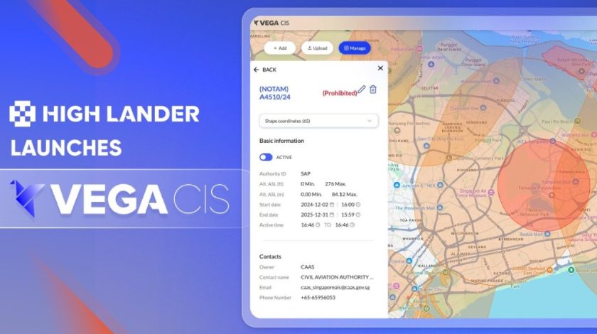
High Lander’s Vega CIS is a tool designed for airspace managers (i.e. ANSPs, air traffic management, aviation authorities) to create airspace constraints, perform Dynamic Airspace Reconfiguration (DAR), and share geo-awareness data in real time with UTM/USSP service providers and UAS operators. It’s operated via an intuitive desktop-based platform, while an associated mobile app provides airspace data to end-users.
“The dashboard enables the creation of three types of airspace: info zones, where UAS flight plans are automatically approved in accordance with UTM-powered deconfliction and prioritization protocols; restricted zones, where authorities customize and authorize permissions; and prohibited zones, where UAS flight plans will be automatically denied. Airspace restrictions can be customized in granular detail according to variables including UAS size and class, mission details and regulatory approvals. Additionally, authorization can be granted manually if required.
The Vega CIS dashboard streamlines a complex process that until now had required considerable time, expertise and red tape to complete. The solution’s innovative NOTAM engine further saves time and effort by automatically converting coded text-based notices into visualized airspace constraints on the dashboard map.
Crucially, by enabling ecosystem-wide data synchronization both directly and via discovery and synchronization service (DSS), Vega CIS provides the basis for digital airspaces where UAS can operate at scale in safety, even when under the control of diverse operators and service providers.”
For more information
https://www.linkedin.com/pulse/high-lander-launches-proprietary-common-information-service-ysb5f/?trackingId=bBw2RXt5tMqsNRm384WAgQ%3D%3D