The second phase of the Drone-Based Door-Step Diagnostic Services (DBDS2) initiative, led by the Department of Health and Family Welfare of the Government of Arunachal
Read more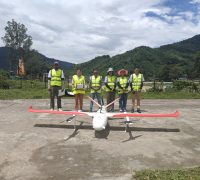
The information portal for unmanned air system traffic management (UTM) and counter-UAS (C-UAS) systems


The information portal for unmanned air system traffic management (UTM), urban air mobility (UAM), counter-UAS (C-UAS) and space traffic management systems
The second phase of the Drone-Based Door-Step Diagnostic Services (DBDS2) initiative, led by the Department of Health and Family Welfare of the Government of Arunachal
Read more
Australia’s Civil Aviation Safety Authority (CASA) said on August 6 that holders of remotely piloted aircraft operator’s certificate (ReOC) who obtain CASA approval to fly
Read more
Blueflite’s patented delivery drone COBALT has been officially registered as a Remote ID compliant uncrewed aerial system (UAS) by the Federal Aviation Administration (FAA). Remote
Read more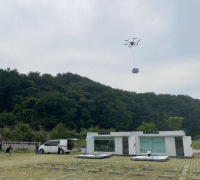
The Republic of Korea’s Ministry of Land, Infrastructure, and Transport (MOLIT) has announced that 14 municipalities, selected in March for the drone demonstration city project,
Read more
Orkid, a developer of VTOL drone technology, has signed a letter of intent to supply eVTOL drones to Flyzz, in order to provide drone deliveries
Read more
RigiTech is helping the SAFIR-Ready project, which is part of the SESAR 3 Joint Undertaking, to develop improvements to the API of the company’s networked
Read moreA new Detect and Avoid (DAA) platform which identifies and tracks drones and other aircraft was deployed at last week’s Farnborough International Airshow. The Arrow
Read more
The European Commission Implementing Decision (EU) 2024/2103 of 30 July 2024 on harmonised standard for direct remote identification for unmanned aircraft drafted in support of
Read moreA consortium led by AeroVision Canada along with principal partners ANRA Technologies and ClearSky Connect, has been selected by Transport Canada, the Canadian aviation authority,
Read more
SkeyDrone detected more than 1000 drone flights over the Tomorrowland music festival, held in Boom, Belgium, over the last two weekends of July. The event
Read more