Kittyhawk, is introducing secure multi-party, multi-channel video and audio streaming, native UAS Facility Maps, new notification and telemetry sharing options with a focus on enhanced security and visibility.
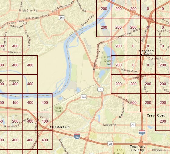
New UAS Facility Maps show the maximum altitudes around airports where the FAA may authorize Part 107 UAS operations without additional safety analysis. “The maps should be used to inform requests for part 107 airspace authorizations and waivers in controlled airspace. There are nearly 500 airports with published FAA Facility Maps that will come online at the completion of the Low Altitude Authorization and Notification Capability (LAANC) pilot program,” said the company. “These maps remove ambiguity on whether or not a flight could be approved, whether with LAANC or manual authorizations. Each of the facility squares are color coded according to the maximum altitude allowed, or flight ceiling. Now, users have a beautiful, intuitive flight planning map available to them for all of the current and future LAANC compatible sites.”
“As the FAA is completing the LAANC pilot program, we thought it was important for Kittyhawk to continue leading the charge for private industry to support their efforts with our products. These new maps add clarity and transparency from what was relatively opaque data,” said Joshua Ziering, Founder & Chief Pilot.
Kittyhawk’s new telemetry-sharing options add greater control with a focus on security and visibility. Enterprise teams now have three new options for how telemetry is viewed within an organization, within the Kittyhawk platform, and across the national airspace via industry partners.
“First, the Private (Team Only) option allows only the members within your team to view live telemetry, both from the app and the web. Second, the Kittyhawk UTM option shares anonymized information and telemetry of live flights to improve airspace awareness and deconfliction. Third, Kittyhawk Extended shares flight information to third parties like airports, schools or AirMap, for example, as well as within the Kittyhawk UTM,” said Kittyhawk.
“In addition to enhanced telemetry controls, Flight Deck now includes DJI’s Local Data Mode. DJI recently implemented this feature in its flight controller and SDKs to help address security concerns about sensitive data unintentionally going to DJI. With this enabled, there is no communication at all with DJI. Even with Local Data Mode enabled, Kittyhawk connections, telemetry, and data flow are not affected.”