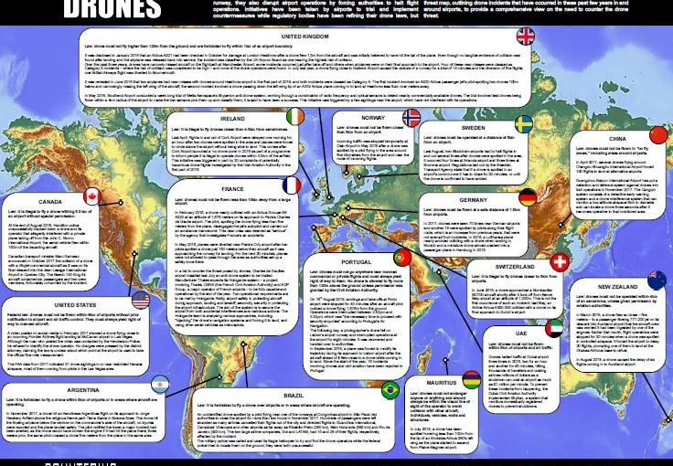
Defence IQ has published its Drone and Airport Global threat map, which highlights some of the most significant near misses between drones and manned aircraft in and around the world’s airports. These include:
- UK – In January 2018, an Airbus A321 had been checked in October for damage at London Heathrow after a drone flew 1.5m from the aircraft and was initially believed to have hit the tail of the plane. Even though no tangible evidence of collision was found after landing and the airplane was released back into service, the incident was classified by the UK Airprox Board as one bearing the highest risk of collision. Over the past three years, drones have narrowly missed aircraft on the flightpath at Manchester Airport; some incidents occurred just after take-off and others when airplanes were on their final approach to the airport. Four of these near-misses were classed as Category A incidents – where the risk of collision was considered to be high – and none of the drone operators were found. In July last year, a drone flying close to Gatwick Airport caused the closure of a runway for a total of 14 minutes and the diversion of five flights; one British Airways flight was diverted to Bournemouth – more text follows.
- Dubai – Drones halted traffic at Dubai airport three times in 2016, two for an hour and another for 90 minutes, hitting thousands of travellers and costing airlines millions of dollars as a shutdown can cost an airport as much as $1 million per minute. To prevent these incidents from happening, the Dubai Civil Aviation Authority implemented Skytrax, a system that monitors domestically registered drones to prevent shutdowns.
- China – In April 2017, several drones flying around Chengdu Shuangliu International Airport forced 100 flights to land at alternative airports. Guangzhou Baiyun International Airport has put a detection and defence system against drones into trail operations in November 2017. The Cangqin system consists of a detective early warning system and a drone interference system that can monitor a low-altitude airspace 8km in diameter and can locate a drone three seconds after it becomes operative in that monitored area.
For more information:
https://counteringdrones.iqpc.co.uk/downloads/drones-and-airports-global-threat-map?-ty-m